Good morning. This is Alex Marienthal with the Gallatin National Forest Avalanche Forecast issued on Sunday, March 24th at 6:45 a.m. Today's forecast is sponsored by Highline Partners and Cooke City Super 8/Bearclaw Bob’s. This forecast does not apply to operating ski areas.
Since yesterday morning the mountains have no new snow. This morning temperatures range from high 20s F in the Bridger Range to teens F near Cooke City, and mid-20s F elsewhere. Wind is 5-15 mph out of the east to northeast. Today wind will be 5-15 mph out of the east-southeast. Temperatures will reach high 30s F with increasing clouds and light snow and rain this afternoon. By tomorrow 1-3” of snow is possible in the southern mountains with 1” possible near Bozeman.

All Regions
The past week of daily above freezing temperatures and sun created a wet snowpack on mid-low elevation slopes and slopes that receive direct sunshine. Overnight, below freezing temperatures formed a frozen crust on the snow surface which makes the snowpack generally stable this morning. Today, above freezing temperatures and some sunshine will melt this crust and make wet snow avalanches possible. Cloud cover and snowfall this afternoon will reduce wet snow avalanche activity, but any rain will weaken the snowpack and increase the chances of natural and human triggered avalanches. If the snow surface is wet and unsupportive move to lower angle or cooler, shady slopes.
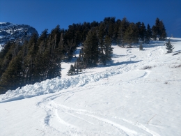
Yesterday afternoon skiers in the northern Bridger Range triggered a small, powerful wet slab (details). This is a reminder that wet slab season is here, and is similar to a timber sled triggered avalanche that buried a rider up to his waist on Thursday (details). Yesterday we went to Saddle Peak and found a wet, unstable snowpack on sunny slopes and the surface crust melted by late morning. We found a dry, generally stable snowpack on high elevation shady slopes (video).
See our photos page for a look at recent natural and human triggered wet slab avalanches. Today these types of slides are possible on slopes where the snow surface is wet and unsupportive. Even small wet slabs can be powerful and the debris sets up like concrete. Be cautious of steep terrain above you where natural wet slides could start, similar to a slide on the Sourdough Canyon trail last Thursday (details). Anticipate decreasing stability as temperatures warm through the day, especially on low elevation slopes and slopes that receive direct sun. The avalanche danger is LOW this morning and will rise to MODERATE this afternoon.
If you get out and have any avalanche or snowpack observations to share, contact us via our website, email (mtavalanche@gmail.com), phone (406-587-6984), or Instagram (#gnfacobs).
Upcoming Avalanche Education and Events
Spring is here and wet snow avalanches are becoming a daily concern. Anticipate decreasing stability while forming a travel plan. This article from Backcountry Magazine highlights some things look for that indicate when it is time to turn around.