Good Morning. This is Eric Knoff with the Gallatin National Forest Avalanche Advisory issued on Thursday, April 5th at 7:00 a.m. Today’s advisory is sponsored by the Yellowstone Arctic Yamaha and Yamaha Motor Corp in partnership with Friends of the Avalanche Center. This advisory does not apply to operating ski areas.
Over the past 24 hours the Bridger Range picked up 6-8” of high density snow. The mountains around Big Sky and Cooke City picked up 3-6” while the mountains around West Yellowstone picked up 1-2”. This morning it’s still snowing lightly in the northern mountains and temps range from the mid to high 20’s F. Winds are blowing 20-40 mph out of W-SW in the mountains around Bozeman, Big Sky and Cooke City and 15-25 mph in the mountains near West Yellowstone. Today, highs will warm into the upper 20’s to low 30’s F and winds will remain moderate to strong out of the W-SW. Light snow will continue in the northern mountains which will see another 1-3” by this afternoon. Heavier snow returns tonight dropping an additional 4-6” in the northern mountains and Cooke City. The mountains around West Yellowstone will receive 2-4”.

Overnight the Bridger Range received 6-8” of high density snow totaling 1” of SWE (snow water equivalent). Fortunately, the snowpack in the Bridger Range is strong, which will keep avalanche problems confined to the new snow. The mountains around Big Sky and Cooke City picked up 3-6” totaling .3-.5” of SWE. Although not as much as the Bridger Range, it’s still enough to elevate the avalanche hazard.
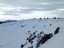
The main problem today will be wind loaded slopes (video). West-southwest winds gusting 30-40 mph will easily transport the new snow and form fresh wind slabs, which will be easy to trigger. Watch for wind drifted snow near upper elevation ridgelines, rock bands, and steep convex terrain features (photo). The best defense against avalanches today will be conservative terrain selections that avoid wind loaded slopes.
Additional concerns will be storm slabs and loose dry avalanches (sluffs) (video). Pay close attention to how the new snow is bonding to the old snow surface and avoid steep, consequential terrain if the new snow slides easily.
Today, dangerous avalanche conditions exist on wind loaded slopes which have a CONSIDERABLE avalanche danger. Non-wind loaded slopes have a MODERATE avalanche danger.

Yesterday, Doug and his partner rode into Carrot Basin in the southern Madison Range and found wind loaded slopes and cornices to be the primary avalanche problems (video, photo). The lack of new snow and calmer winds overnight won’t do much to increase the avalanche hazard today. However, triggering a wind slab remains a possibility, primarily on exposed upper elevation slopes. Today, watch for and avoid thick wind drifts and steer clear of large, overhanging cornices.
Outside of wind loaded slopes, the snowpack lacks buried weak layers and is generally stable.
In the mountains near West Yellowstone, human triggered slides are possible on wind loaded slopes which have a MODERATE avalanche danger. Non-wind loaded slopes have a LOW avalanche danger.
If you get out and have any avalanche or snowpack observations to share, drop a line via our website, email (mtavalanche@gmail.com), phone (406-587-6984), or Instagram (#gnfacobs).
Info and Announcements
Our last daily advisory will be this Sunday, April 8th. Afterward, we will issue weather and snowpack updates on Monday and Friday mornings for most of April.
Hyalite Canyon road is closed to vehicles and reopens May 16th.
Send us your observations on Instagram! #gnfacobs
Posting your snowpack and avalanche observations on Instagram (#gnfacobs) is a great way to share information with us and everyone else this spring.