Good Morning. This is Eric Knoff with the Gallatin National Forest Avalanche Advisory issued on Saturday, December 23th at 7:00 a.m. Today’s advisory is sponsored by Yellowstone Arctic Yamaha and Yamaha Motor Corp in partnership with the Friends of the Avalanche Center. This advisory does not apply to operating ski areas.
A cold northwest flow has favored the mountains around Bozeman, Big Sky and Cooke City. Over the past 24 hours, the northern Madison Range (Big Sky) has received 10-14” of low density snow. The mountains around Bozeman and Cooke City picked up 8-10” while the mountains around West Yellowstone picked up 4-6”. At 5 a.m. it’s still snowing lightly around Big Sky, but mostly dry elsewhere. Temps are in the single digits above or below zero and winds are blowing 10-25 mph out of the west-northwest. Today, light snow showers will linger in the northern mountains as the area remains under a northwest flow, but no real accumulation is expected. Temps will remain cold today with highs in the single digits and winds will stay out of the west-northwest at 10-20 mph. Tomorrow looks to be cold and dry.

Although the Lionhead area received the least amount of snow out of this storm, it has the weakest snowpack and most dangerous avalanche conditions. A collapsible layer of facets sitting over the Thanksgiving Ice curst is the most problematic layer. This problem likely exists on all aspects and elevations. On Thursday, snowmobilers got this layer to propagate easily in stability tests and avoided all steep terrain (video).
Today, I would be extra cautious when traveling on or underneath any slopes steeper than 30 degrees. Avalanches have the potential to be triggered from a distance or low on the slope. It’s mandatory under these conditions that skies and riders only expose one person at a time in steeper terrain and always watch each other from a safe location.
Today, an unstable structure makes human triggered avalanches likely on all slopes and the avalanche danger is rated CONSIDERABLE.
This was a classic cold smoke storm that heavily favored the northern ranges and Cooke City. Big Sky topped the charts with 16-18” over the past day and half. The mountains around Cooke City received a similar amount while the Bridger Range squeezed out 12-14”. This sounds like a ton of snow, which it was, but it was very low density and did not add a significant amount of weight to the snowpack. Most areas only received .5 to .7” of SWE.
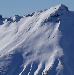
Today, the main avalanche concerns will be wind slabs and loose snow avalanches (sluffs). Wind slabs will be most prevalent in terrain leeward to west-northwest winds (photo, photo). These slabs will be sensitive to human triggers and have the potential to entrain large volumes of snow once they get moving. Loose snow avalanches also have potential to pick up heavy amounts of snow once they get rolling in steep terrain.
A secondary concern is avalanches failing on a layer of facets buried a few feet deep. This layer hasn’t been highly reactive, but has produced signs of instability and few recent avalanches. Yesterday, Alex was in Cooke City and did not get this layer to propagate in stability tests (video). However, a few recent avalanches have been observed around Cooke City that appear to have failed on this layer (photo). This problem is tricky because the strength and distribution of this layer is highly variable. It’s worth digging down a few feet and doing a stability test before committing to steeper terrain (video).
Today, wind slabs will be easy to trigger and the avalanche danger is rated CONSIDERABLE on wind loaded slopes. Non-wind loaded slopes have a MODERATE avalanche danger.
If you get out and have any avalanche or snowpack observations to share, drop a line via our website, email (mtavalanche@gmail.com), phone (406-587-6984), or Instagram (#gnfacobs).
Upcoming Avalanche Education and Events
BOZEMAN
Jan. 12 and 13, Companion Rescue Clinic, Info and Register
Jan. 17, 18 and 20 or 21, Introduction to Avalanches w/ Field Day, Info and Register Here
Jan. 24, 25 and 27, Advanced Avalanche Workshop w. Field Day, Info and Register Here
Feb. 9 and 10, Companion Rescue Clinic, Info and Register
WEST YELLOWSTONE
Jan. 6, Avalanche Awareness, 7-8 p.m. at West Yellowstone Holiday Inn Conference Center
COOKE CITY
Today, Avalanche Rescue, anytime between 10-2 @ Lulu Pass road.
Check out Chabot’s article, Being Prepared that was just published in the Chronicle’s CARVE magazine this weekend. In essence, preparation decreases the chance for negative outcomes.