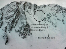
Advisory Archive
At 6 a.m. it just started snowing around Big Sky with an inch falling. Mountain temperatures are 5-10F with southwest winds at 15-25 mph. The Bridger Range is calmer and warmer with 5-10 mph winds and temperatures in the teens. Today will be cloudy as temperatures rise into the upper teens with light to moderate southwest winds. Tonight winds will switch to the northwest, but speeds will not increase much. Scattered snow showers will drop 1-3 inches by morning.

This morning is when we all found out if we’ve been naughty or nice, as if we didn’t already know. Santa is a judgmental soul but still brought most of us gifts of snowfall: 5 to 6 inches in the northern Gallatin and Madison Ranges, 3 to 4 inches in the southern mountains and just a trace, the equivalent of a lump of coal, to the Bridger Range. Winds spiked yesterday afternoon to 30 mph for a couple hours, but otherwise have been light at 10-15 mph out of the west. Mountain temperatures are in the single digits and will only rise into the teens today under clearing skies. No new snow is expected in the next 24 hours.
Over the past 24 hours the mountains around West Yellowstone and Cooke City picked up 2-3 inches of snow. The southern Madison Range and mountains around Big Sky including the northern Gallatin Range picked up 1-2 inches. The Bridger Range has remained dry. Today, the southern ranges will see an additional 3-5 inches while the north will pick up 2-4 inches. Currently, temperatures are in the teens F and winds are blowing 10-20 out of SSW. Today, highs will reach into the 20s F and winds will remain out of the WSW at 10-20 mph. Snow will taper off this evening as the storm pushes east. Very little snow is expected tonight and Christmas Day looks to be dry.
Overnight a fast moving weather disturbance dropped 2-3 inches of snow in the mountains around West Yellowstone and Cooke City including the southern Madison Range. The mountains around Bozeman and Big Sky picked up a trace to one inch. Currently, temperatures are in the teens F and winds are blowing 10-20 out of the SSW with gusts reaching close to 30 mph. Today, highs will climb into the 20s F under partly to mostly cloudy skies. Winds will continue to blow 10-20 from the SSW. A more potent storm will impact our area tonight and tomorrow. 1-3 inches is possible by morning with 4-6 inches likely by tomorrow afternoon.
This morning mountain temperatures were in the teens to low 20s F with a slight inversion and valley temperatures in the single digits or colder in places like West Yellowstone. Winds this morning were blowing 10-15 mph from the south with gusts of 20-30 mph. Today cold air will descend over SW Montana keeping mountain temperatures from rising much. As a trough of low pressure approaches, south winds will increase and clouds will build this afternoon. Snowfall should begin late afternoon or early this evening mostly to the south. By tomorrow morning the mountains near West Yellowstone and Cooke City will get 3-5 inches of snow. Other areas will get 1-3 inches.

Dry and windy weather continues. This morning temperatures were in the teens F and southerly winds were blowing 15-25 mph with gusts of 40-60 mph at the highest ridgetops. The exception is the Bridger Range which had temperatures in the low 20s F and calmer winds. Today will be partly sunny and temperatures will rise into the low 20s F while the Bridger Range could see temperatures approaching 30 F. Strong south winds will continue and only slightly ease by late afternoon. Light snowfall should come sometime Sunday with more possible for Christmas.
This morning temperatures were in the single digits F and ridgetop winds were blowing 15-20 mph from the W and SW with gusts of 30 mph. Major low pressure systems are impacting the west coast and the Midwest, but southwest Montana remains under a ridge of high pressure. Fortunately this ridge will flatten and move east this weekend. Today temperatures will climb into the teens F, and winds will increase and blow 25-40 mph from the SW.
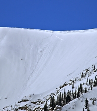
Under clear skies mountain temperatures are zero to minus five with light westerly winds. There’s no new snow to report, the first time in 14 days. Today will be sunny with temperatures rising into the low teens. Winds will blow 10-20 mph out of the west, but become stronger from the southwest tonight. A high pressure system will keep skies clear and dry for the next two days.
Since 5 a.m. yesterday morning the mountains picked up 3-4 inches of snow, with Cooke City getting eight inches. Winds are blowing 20-30 mph out of the west, a decrease from yesterday’s gusts that hit 50-60 mph. Mountain temperatures are in the chilly single digits. Today will be partly cloudy with only slight warming. Winds will continue out of the west, but become light. Scattered snow flurries will drop a trace to one inch of new snow by morning. Overall it’s a cold, calm, winter day.

Over the past 24 hours the mountains around Cooke City and West Yellowstone including the southern Madison Range picked up 4-5 inches of snow. The mountains around Bozeman and Big Sky picked up 1-2 inches. Today, an additional 3-4 inches will fall in the southern mountains including the northern Madison Range while the Bridger Range and Northern Gallatin Range will see 1-2 inches. Currently, temperatures are in the mid-teens to low twenties F and winds are blowing 20-30 mph out of the WSW with gusts over 50 mph in Hyalite and Big Sky. Today will be the warmest day of the week with highs reaching close to 30 degrees F. Winds will remain strong out of WSW blowing 20-30 mph with upper elevation gusts reaching 50 mph. Temperatures will drop this evening as conditions begin to clear and tomorrow will be a colder and drier day.