Advisory Archive
No new snow has fallen since yesterday morning and cold, clear weather has settled into southwest Montana. This brief cold snap is producing some of the coldest temperatures we’ve seen in months. At 4 a.m. Fisher Creek Snotel site near Cooke City is recording a temperature of -16 F. Other mountain locations are showing temps between -5 and -10 F. Today, highs will warm into the teens F under sunny skies and winds will remain calm. High pressure will dominate the weather pattern over the next 24 hours and no new snow is expected.

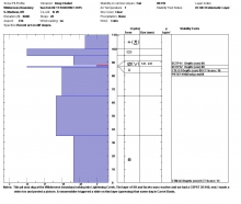
Since yesterday morning another 5 inches fell in the Bridger Range, over a foot in the northern Gallatin Range, and 4-8 inches in the northern Madison Range. Further south, Cooke City and the southern Madison Range got 2-4 inches while the mountains near West Yellowstone got a trace at best. Temperatures this morning were in the low to mid teens F with north winds blowing 5 mph gusting 15 mph. In the Bridger Range, winds were blowing from the E at 15-20 mph.
As cold air descends over the area today, temperatures will drop a few degrees, and snowfall will end around midday. A few more inches may accumulate mainly near Bozeman and Big Sky, and winds may increase some this afternoon.
By 6 a.m. this morning the mountains near Bozeman and Big Sky had received 3-6 inches of snow, the mountains near Cooke City had received an inch, and the mountains near West Yellowstone remained dry. Temperatures were in the upper teens and low 20s F with winds blowing 15 mph gusting 25 mph generally from the NW. Snowfall will continue today, winds should continue from the NW at 15-25 mph, and temperatures may only warm a few degrees. By tomorrow morning, the mountains near Bozeman and Big Sky should get another 4-6 inches and the mountains further south may get 2-3 inches.


This morning temperatures were in the upper 20s F and westerly winds were blowing 20 mph gusting 30 mph. Temperatures were a little cooler and winds were a little calmer near West Yellowstone and Cooke City. Today will have sunshine for much of the day with clouds building in the afternoon. Temperatures will climb into the 30s F but cold air from the north will move over the area today bringing colder temperatures for this weekend. Winds will continue blowing 20-30 mph mostly in the Bridger Range but ease this afternoon. An inch of snow could fall by Friday morning with more coming during the day.

Under partly cloudy skies temperatures are 10-15F in the south and 20F in the northern ranges. Winds are currently west at 20-30 mph with gusts of 40 last night in Hyalite. Today will be mostly sunny and warm with temperatures rising into the high 30s. Winds will increase later this afternoon and high clouds will filter in. Today and tomorrow will be spring-like, but “Winter” is scheduled to return from her vacation in Boston and show up to work first thing Friday morning.
Under clearing skies mountain temperatures are a chilly 5F to 10F. Winds are currently blowing 10-20 mph out of the west to northwest except in Cooke City where they are much stronger and gusting to 35 mph. Today will warm into the upper 30s with moderate winds. High pressure will block any chance of precipitation and sunny spring-like weather is forecasted tomorrow. The big question is, do I keep my snow shovel on my porch or my skateboard?
Winter is working hard to make an appearance. Over the past 24 hours most mountain locations picked up 3-5 inches of low density snow with the exception of the mountains near West Yellowstone which picked up around one inch. Temperatures are also the coldest they have been in weeks. At 4 am, mountain temperatures are in the single digits to mid-teens F and winds are light out of N-NW. Today, a northwest flow aloft will continue to produce light snow showers in the mountains, although no real accumulation is expected. Temperatures will warm into the upper teens to mid-20s F and winds will remain light out of N-NW. Winter will try and stick around until tomorrow then spring like conditions return on Wednesday.

Overnight the northern Gallatin Range picked up 1” of new snow while the rest of the advisory area remained dry. This morning, mountain temperatures are actually below freezing and range from the upper teens to mid-20s F under partly to mostly cloudy skies. Winds are blowing 10-20 mph out of the W-NW. Today, skies will remain partly to mostly cloudy and temperatures will warm into the upper 20s to low 30s F. Winds will continue to blow 10-20 mph out of the W-NW. No accumulating snowfall is expected over the course of the day. There is a better chance of precipitation tonight and tomorrow. The mountains should receive 1-3” of snow by tomorrow afternoon.
Spring like weather continues around southwest Montana. At 4 am temperatures range from the upper 20s to upper 30s F and winds are blowing 10-20 out of the W with gusts around Big Sky reaching 30 mph. Today, near record highs are possible around much of the region. By this afternoon mountain temperatures will warm into the mid to upper 40s F under partly to mostly cloudy skies. Winds will continue to blow 10-15 mph out of the W-NW with stronger gusts possible in upper elevation terrain. A weak storm system is approaching from the west which will produce increasing clouds throughout the day. Light rain and snow showers are possible in the mountains by late afternoon. The mountains could pick up 1-2 inches of snow by tomorrow morning.
Yesterday high temperatures in the mountains reached the low to mid 40s F, and this morning temperatures had dropped to a few degrees either side of freezing. Westerly winds were blowing 15-30 mph. Today will have more sunshine with temperatures reaching the 40s F again. Winds should ease this afternoon. Some snow should come tomorrow with cooler temperatures.