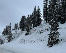
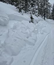
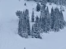
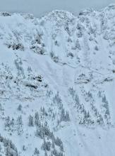
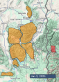
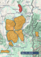
Advisory Archive

Totals from snow that fell during the day yesterday are:
- 7” (0.7”snow water equivalent (SWE)) in Hyalite.
- 3-5” (0.3-0.5” SWE) in Big Sky.
- 4” (0.4” SWE) Cooke City.
- 3” (0.3” SWE) Bridgers and Taylor Fork.
- 2” (0.2” SWE) West Yellowstone and Island Park.
Temperatures are teens to low 20s F this morning, and will be teens and 20s F today. Yesterday winds increased to moderate out of the northwest at 10-20 mph with gusts to 25-40 mph. This morning winds are from the southwest at 5-15 mph, and today wind will remain light out of the west.
Snowfall is forecast this afternoon through tonight, favoring the mountains near Bozeman and Big Sky with 4-8” by morning, and 1-3” near Cooke City, West Yellowstone and Island Park.


Since yesterday morning snowfall amounts are:
- 4-5” (0.4-0.5” snow water equivalent (SWE)) in Cooke City, Bridgers, Big Sky.
- 2-3” (0.2-0.3” SWE) in Hyalite, Taylor Fork, West Yellowstone, Island Park:
Temperatures are low 20s to low 30s F this morning, and will be in the 20s F today. Wind has been out of the southwest, and increased overnight to 5-20 mph with gusts of 35-45 mph. Today the wind will shift and be from the northwest at 5-15 mph with gusts to 20 mph.
Another round of snowfall is starting this morning, favoring the mountains near Bozeman and Big Sky with heavy snow possible during the day. By this evening, 4-8” of snow could fall in the Bridger Range, Hyalite and near Big Sky with 2-3” elsewhere.

In the last 24 hours, it has snowed:
10” (1.0” Snow Water Equivalent) in Cooke City
3-5” (0.4-0.6” SWE) near Big Sky, West Yellowstone, Island Park
2” (0.2” SWE) in Hyalite
Temperatures rose overnight in many areas and are in the mid-high 20s F this morning. Winds are 20-25 mph out of the southwest and west (a bit lighter in the Bridgers), with gusts of 30-40 mph.
Snowfall may be intense at times this morning, tapering off this afternoon before another round of snow hits tomorrow. By tomorrow morning, expect 6-8” of new snow near Cooke City, 4-6” near West Yellowstone, Island Park and Big Sky, and 3-5” around Bozeman. Winds will remain moderate and westerly. High temperatures will rise to near freezing in many areas.


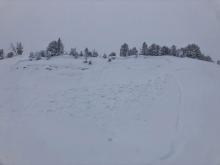
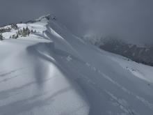
If you like cold, snowy weather with lots of powder, it doesn’t get any better than now. Skiing and riding conditions are 5-star, and light snow is falling this morning. A quick look at any weather forecast shows more snow coming at least into next week.
This morning, most areas received 3-5 inches of new snow in the last 24 hours, some falling yesterday and some this morning. 0.1-0.2 inches of SWE in northern forecast zones and 0.3-0.4 in southern zones. Temperatures are mostly in the low teens F. Winds are barely blowing in the Bridgers. In all other areas, winds are blowing 10-15 mph gusting to 25 mph generally from westerly directions.
Today another inch or so of snow should fall and then a few more inches tonight. Areas near West Yellowstone, Island Park, & Cooke City could get more with 3-5 inches tonight. Temperatures will warm into the low 20s F, and winds may increase some. Heavier snowfall should arrive with a warm front sometime tomorrow into Saturday.


Yesterday morning a bit more snow trickled into the Bridger Range and northern Gallatin and Madison Ranges. Higher elevations received 2-3 inches.
This morning it’s cold with temperatures around 5 degrees F in most places. Winds picked up since yesterday averaging 15-25 mph gusting to 40 mph from the W and SW. Winds in the Bridger Range are surprisingly light blowing 5 mph gusting to 10 mph.
Today cloudy skies will deliver more snow and temperatures will struggle to pull out of the single digits into the low-mid teens F. Winds should continue from the W and SW mostly at the same speed but may increase some this afternoon.
Snowfall should start around late morning. Most areas will see some snow with 1-3 inches falling The mountains near Island Park and West Yellowstone should get the most snow and wind. By tomorrow morning, the Island Park area should have 5-7 inches of snow and the West Yellowstone area should have 2-4 inches.


This morning, temperatures are in the single digits and teens F with 5-10 mph winds from the west and the southwest. Winds are 15 mph, gusting to 30 from the west in the Bridger Range.
24 Hour Snow:
- Bridger Range: 20” of new snow with 1.6” of snow water equivalent (SWE)
- Northern Gallatin and Northern Madison Ranges: 4-8” of snow
- Centennial Range: 1” of snow
Today, temperatures will be in the teens and 20s F with 5-10 mph wind from the west and southwest. Light snowfall will result in a trace to an inch of new snow across the advisory area by tomorrow morning.


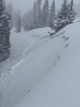

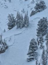
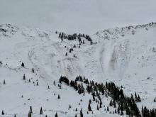
Snowfall was steady through yesterday, with heavy snow continuing to add up in the Bridgers this morning. 24 hr Storm totals are:
- 8" = 1.2" SWE in the Bridgers
- 6" = 0.6" SWE in Hyalite
- 6" = 0.6" SWE in Big Sky
- 7" = 0.9" SWE Taylor Fork
- 5" = 1.0" SWE West Yellowstone
- 8" = 1.4" SWE Island Park
- 11" = 1.4" SWE Cooke City
Yesterday wind was strong out of the west and southwest at 15-30 mph with gusts of 35-60 mph. This morning, wind is out of the northwest-north at 5-15 mph with gusts of 20-30 mph, and temperatures are teens to low 20s F.
Today, temperatures will be high teens to low 20s F, wind will be out of the northwest at 5-10 mph with gusts to 20 mph. Snowfall will be light in the southern mountains with 1-2” possible by tomorrow. Near Bozeman and Big Sky, snowfall will increase this morning with 6-10” of snow possible during the day and a 2-3” more tonight.


Since yesterday morning the mountains near Cooke City and Island Park received 5” of new snow, 2-3” fell near West Yellowstone and Big Sky, and 1” near Bozeman. Wind has been out of the west, southwest and south at 15-25 mph with gusts of 30-50 mph. Temperatures are teens to 20s F this morning.
Today, temperatures will reach high 20s to low 30s F, and wind will be out of the southwest and west at 10-20 mph with gusts to 30 mph. Snowfall is expected to start this morning, and will be intense at times through tonight. By tomorrow morning the mountains could have 8-15” of new snow. Forecasts favor Cooke City and Island Park to get the higher end of that range.


This morning, mountain temperatures are in the teens and 20s F with 15-25 mph winds from the west and southwest. In the last 24 hours, most of the forecast area has received 2-4” of new snow (0.2-0.3” Snow Water Equivalent - SWE), with a trace to 1” near Bozeman.
Storm Totals Since Wednesday:
- Big Sky – 12-15” (1” SWE)
- Island Park, West Yellowstone, and Cooke City – 8-13” (0.7-1.1” SWE)
- Bridger and Northern Gallatin Range – 5-8” (0.5-0.7 SWE)
Today, high temperatures will reach the 20s and low 30s F with 15-25 mph winds from the west and southwest. The mountains near Island Park, West Yellowstone and Cooke City will receive 4-7” of snow by Sunday morning, with 1-2” near Bozeman and Big Sky.
There are 5-7” of new snow (0.4-0.6” Snow Water Equivalent) across most of the advisory area, with only 3” in Hyalite. Winds are 15-25 mph out of the west, with gusts of 30-50 mph. Temperatures this morning are in the teens and 20s F.
Today, 3-5” of snow will fall in Island Park, with 1-3” across the rest of the advisory area. Winds will be 10-20 mph with gusts up to 30 mph out of the southwest. High temperatures will be in the 20s F.
An additional couple inches of snow are possible across the advisory area tonight. Snowfall will continue tomorrow and through the weekend.