This is Ian Hoyer with the Gallatin National Forest Avalanche Forecast on Friday, December 6th at 7:00 a.m. Today’s forecast is sponsored by Spark R&D and Gallatin Valley Snowmobile Assoc.. This forecast does not apply to operating ski areas.
There is no new snow this morning. Temperatures are high teens to mid-20s F and winds are 5-15 mph out of the south and west. Today, temperatures will reach high 20s to mid 30s F. Winds will be 5-15 mph out of the southwest. A trace of snow is possible tonight. More substantial snowfall will begin tomorrow afternoon, favoring the southern ranges.
The snowpack in the Madison Range, Southern Gallatin Range, and Lionhead area has a weak foundation of sugary, faceted snow (photo, video, video, video). As each additional day passes since the last snowfall, avalanches are slowly becoming less likely. However, triggering an avalanche remains possible on slopes with a cohesive slab capping the weak snow at the ground. Before getting onto a steep slope quickly dig down to see if you have this worrisome combination of slab and weak layer. If you find this combo, evaluate it carefully or stick to lower angled terrain.
The avalanche danger is MODERATE today.
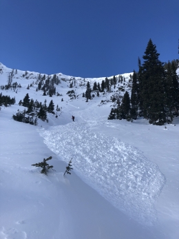
Triggering avalanches remains possible on heavily wind loaded slopes in the Bridger Range, Northern Gallatin Range and around Cooke City. Yesterday, Bridger Bowl Ski Patrol triggered several large avalanches breaking under hard slabs of wind drifted snow near the ridgeline. Alex went up to take a look at these slides and found they were breaking on a thin layer of weak snow low in the snowpack (video). You can trigger similar slides today on high elevation slopes with thick drifts of windloaded snow (e.g. Saddle Peak). Hard slabs are a difficult problem to manage, you will likely not see any signs of instability until you hit just the wrong spot and trigger a large slide.
Slopes without thick winddrifts are generally stable. However, digging to evaluate the snowpack for yourself on a particular slope is the best way to avoid an unpleasant surprise.
Today, avalanches are possible on wind loaded slopes where avalanche danger is MODERATE. On non-wind loaded slopes avalanche danger is LOW.
If you get out, please send us your observations no matter how brief. You can fill out an observation form, email us (mtavalanche@gmail.com), leave a VM at 406-587-6984, or Instagram (#gnfacobs).
Backcountry Barriers Contest
Click here to learn more about the Backcountry Barriers Contest: 1.shortstack.com/NLfNvh
We recognize that backcountry skiing can be daunting. That’s why Ben Goertzen and the Friends of the Gallatin National Forest Avalanche Center have teamed up to help breakdown some of the most prominent barriers of entry to backcountry skiing through this campaign. One lucky winner will be given a complete backcountry skiing kit, a spot in an avalanche awareness course, and featured in a three part video series that ends with an excursion into the backcountry with professional skier and filmmaker, Ben Goertzen. These videos will be used by the Friends of GNFAC to help other aspiring backcountry skiers gain awareness, knowledge and start to breakdown their barriers to entry.
Upcoming Avalanche Education and Events
Our education calendar is full of awareness lectures and field courses. Check it out and plan to attend one or two: Events and Education Calendar.
BOZEMAN
December 11, 1-hr Avalanche Awareness, 6-7 p.m. at REI.
December 12, Avalanche Awareness + Beacon Practice, 6-8 p.m. at Story Mill Community Center.
WEST YELLOWSTONE
9 & 10 December, Snowmobile/Ski Introduction to Avalanche w/ Field Course, 12-5p Dec 9 and field day Dec 10. More info and Register Here.
MANHATTAN
December 9, 1-hr Avalanche Awareness, 7-8 p.m. at Manhattan High School.
COOKE CITY
Every Friday and Saturday, Snowpack Update and Rescue Training. Friday, 6:30-7:30 p.m. at the Soda Butte Lodge. Saturday anytime between 10-2 @ Round Lake.
The Gallatin Valley Snowmobile Association deserves a shout-out for putting up new beacon checkers at Taylor Fork and Buck Ridge Trailheads.


