Good morning. This is Doug Chabot with the Gallatin National Forest Avalanche Forecast on Thursday, March 30th at 6:45 a.m. This information is sponsored by onX and Mystery Ranch. This forecast does not apply to operating ski areas.
The mountains received 2-3” of snow in the last 24 hours with temperatures in the low 20s F and light SE-SW wind blowing 10-15 mph with gusts of 23 mph. Snow is starting to fall and will blanket the area with 4-7” by tomorrow morning. Temperatures will remain in the 20s and wind will be light to moderate from the SE-SW. Tomorrow looks to be sunny with more snow forecasted over the weekend.

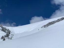
There are a few avalanche concerns today, but none are widespread. The snowfall from the weekend was blown into drifts near the ridgetops which could be triggered; cornices grew and could break; a weak layer of facets might be found a couple feet under the surface; and a weak layer 3-5 feet deep could avalanche, although these are rare.
The first three items on the list are things we can avoid and navigate around: turn around when wind-drifts crack; on ridges make sure your skis or sled are over solid ground instead of a snow overhang; and dig in the upper 3 feet of the snowpack to test the stability of the new snow. For the fourth item, deep slab avalanches, there’s not much you can do other than avoid avalanche terrain or accept that these rare, big slides, are lurking like sharks with you as chum.
Over the last few days there have been natural avalanches in the Bridger Range, up Hyalite, on Buck Ridge, and a couple deep ones a week ago in Hyalite and Cooke City. Avalanches remain possible. To make your pre-trip homework easier check out our Weather and Avalanche Log which has a full listing of the natural and human-triggered slides, and watch our field videos where Ian describes the conditions on Buck Ridge, I talk about digging under the new snow in the Bridger Range and Dave gives advice on terrain selection.
The avalanche danger is rated MODERATE on all slopes.
Please share avalanche, snowpack or weather observations via our website, email (mtavalanche@gmail.com), phone (406-587-6984), or Instagram (#gnfacobs).

There are a few avalanche concerns today, but none are widespread. The snowfall from the weekend was blown into drifts near the ridgetops which could be triggered; cornices grew and could break; a weak layer of facets might be found a couple feet under the surface; and a weak layer 3-5 feet deep could avalanche, although these are rare. Dig, test and turn around if you see any recent avalanches or find instability.
Upcoming Avalanche Education and Events
Events and Education Calendar.
Friday, March 31, 8 p.m. Hyalite Canyon closes for motorized use until May 16.
Avalanches have killed 23 people in the United States so far this season. On Monday, March 27th, a snowmobiler was killed in an avalanche in Utah. This was the tenth fatality in March.
More info on each event is available at the Avalanche.org Accidents Page.