Good morning. This is Ian Hoyer with the Gallatin National Forest Avalanche Forecast on Friday, February 11th, at 7:00 a.m. This information is sponsored by Blitz Motorsports and Yamaha and onX. This forecast does not apply to operating ski areas.
There is an inch of new snow at Lionhead this morning with no new snow elsewhere. Winds have been blowing 15-25 mph out of the northwest and west with gusts of 40-60 mph. Winds will diminish slightly this morning to 15-20 mph with gusts to 30. Temperatures are in the teens and 20s F this morning and will only rise a few degrees today. A trace to an inch of snow is possible this morning across most of the area, before clouds clear and skies become mostly sunny. There is a chance that Cooke City could see up to 4 inches fall today.

Triggering large avalanches remains possible in the mountains around Cooke City. Last weekend’s snowfall and continuing wind drifting have loaded a weak layer buried around a foot and a half under the snow surface (video). This weak layer is categorized as persistent, which means it will stick around and remain an issue for quite a while after being loaded. Winds this morning are the strongest they’ve been since the last snowfall. More snow is being transported and drifting into thicker slabs which could be triggered today. The snowfall forecast today is uncertain, but any new snow will add to the snow available for transport and drifting. Look for collapses, shooting cracks, and especially recent avalanches, as clear signs to avoid avalanche terrain. Large avalanches are possible and the avalanche danger is rated MODERATE.

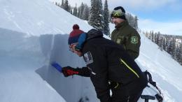
Conditions are generally stable and large avalanches are unlikely across the rest of the advisory area. The primary concern is a weak layer 12-18” under the surface. While this weak layer is widespread it is only unstable in isolated areas where wind drifting has capped it with a dense slab of snow. The small avalanche that killed a snowmobiler last Sunday in Lionhead is a pointed reminder to stay on alert even when avalanches are unlikely (details). Yesterday in the northern Bridger Range I found a snowpack that had been hammered by the wind (and stripped to dirt in many places), leaving generally stable conditions until it snows next (video)
Keep your eyes open for signs of instability and keep adhering to safe travel practices as insurance in case you get surprised by an isolated instability. Always carry rescue gear (beacon, shovel, probe). Go one at a time on steep slopes. And keep an eye on your partners while they’re on those steep slopes. For today the avalanche danger is rated LOW in the mountains from Bozeman to West Yellowstone.
If you get out, please send us your observations no matter how brief. You can submit them via our website, email (mtavalanche@gmail.com), phone (406-587-6984), or Instagram (#gnfacobs).
Upcoming Education Opportunities
See our education calendar for an up-to-date list of all local classes. Here are a few select upcoming
February 11-12, Avalanche Fundamentals + Field Day in ENNIS is perfect as a refresher or an introduction to avalanches. We are introducing a new format with four pre-recorded lectures to watch at your convenience, a live question and answer session, and an in-person field day. Pre-register HERE.
February 19, Women's only Companion Rescue Clinic sponsored in partnership with SheJumps! Register Here.
March 4, Companion Rescue Clinic with the Bozeman Splitfest. Information and registration HERE.
Every Saturday near Cooke City, 10 a.m.-3 p.m. FREE snowpack update and transceiver/rescue training. Stop by for 20 minutes or more at the Round Lake Warming Hut.
We completed our investigation of the avalanche fatality at Ski Hill in Lionhead. A detailed report is HERE, the field video is on our YouTube channel and the incident is recorded on our Accident Reports page.