Good Morning. This is Dave Zinn with the Gallatin National Forest Avalanche Forecast on Wednesday, March 25th at 7:15 a.m. Today’s forecast is sponsored by Uphill Pursuits and Spark R&D.
Bridger parking lots are private property. Please do not loiter, camp overnight or congregate in the parking lots. Please skin, ski, and leave. Ski areas are closed, snowmobiles are not allowed, and backcountry conditions exist (video).
In the last 24 hours, the mountains around Big Sky and Cooke City received 10-12” of new snow, the Bridger, Southern Madison, and Gallatin Ranges received 6-8”, and the mountains around West Yellowstone received 3-5”. Winds were from the southwest to west at 15-25 mph with gusts in the 40s mph before dying down last night except in the Bridger Range which had light wind blowing 5 mph from the west. This morning mountain temperatures are in the teens to low 20s F.
Today, mountain temperatures will be in the 20s F with west to southwest winds at 5-15 mph. Snow will pick up again this afternoon with the Gallatin and Madison Ranges and Cooke City getting 6-8”, the Bridger Range 3-5” and West Yellowstone 2-3”.

In the last 36 hours, the Madison and Southern Gallatin Ranges, and the mountains around Cooke City received 10-12” of new snow equaling 0.7-0.8” of snow water equivalent (SWE). Winds died down around midnight, but not before creating drifts of snow. This adds up to dangerous avalanche conditions today. Avalanches will likely be confined to the upper levels of the snowpack sliding on melt-freeze crusts that formed on many elevations and aspects during recent warm weather (video). Additionally, a weak layer of feathery surface hoar was buried last week in some areas, but not all (photo). Focus your stability assessments on the top several feet of the snowpack to determine how new snow is bonding to the old snow surface and to look for a stripe of weak surface hoar in your snowpit wall.
While unlikely, recent human and cornice triggered deep slab avalanches south of Livingston (outside our area) are stark reminders that we still have weak snow near the ground (photo, photos and details). Stay clear of large cornices completely and minimize your time below them as much as possible (photo).
Today, back off steeper terrain and find some lower angler powder if you see natural avalanches, shooting cracks, wind-drifted snow, or get unstable test results. The danger is CONSIDERABLE on wind-loaded slopes where human triggered avalanches are likely. On non-wind-loaded slopes the danger is MODERATE and human triggered avalanches are possible.

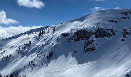
The Bridger Range received 10” of snow (0.9” SWE) with light winds and the Lionhead and Northern Gallatin Ranges got 6-7” of snow (0.4-0.5” SWE) with 15-25 mph wind from the southwest that gusted into the 50s mph (NOTE: We took down the Flanders anemometer this weekend. It was windy there until proven otherwise). At Bridger Bowl yesterday, we found melt-freeze crusts at many elevations and aspects that will act as sliding surfaces for new snow and wind slab avalanches (video). The wind built fresh drifts of snow where it is possible to trigger avalanches today (photo). While unlikely, recent human and cornice triggered avalanches south of Livingston are indicators that weak snow still exists at the bottom of our snowpack. (photo, photos and details). Stay clear of large cornices completely and minimize your time below them as much as possible (photo).
Today, avoid cornices and wind loaded slopes where avalanches are possible, and the danger is MODERATE. On non-wind-loaded slopes larger human triggered avalanches are unlikely, but smaller loose snow avalanches are possible in steeper terrain. The danger is LOW on non-wind-loaded slopes.
We will end daily avalanche forecasts on April 5th and continue with general bulletins every Monday and Friday through April. Over the next couple of weeks, we will take down weather stations and will no longer receive observations from guides and ski patrol. We need help gathering field data. Please send us your observations no matter how brief. You can fill out an observation form, email us (mtavalanche@gmail.com), leave a VM at 406-587-6984, or Instagram (#gnfacobs).
Social Distancing in the Backcountry
We hope all can enjoy the outdoors to ease the stress during this challenging time, and we will continue regular avalanche forecasts into April. It is important we all do our part to reduce the spread of covid-19 in our community. While you are in parking lots and on trails please practice social distancing and other precautions recommended by the city, county and nation (video from county health department). Please do not carpool with people outside your household, keep groups small and don’t have social gatherings in the parking lot (with dogs as well). You can stay up-to-date on COVID-19 in Montana and globally on the Montana Department of Health and Human Services website. Be patient and courteous. Step aside for other groups to pass. Smile, communicate, say hi, “go ahead” and “thank you”. Dial back your objectives and slow down to minimize the risk of injury and overtaxing local EMS services. Help each other and stay safe. Thank you.
Upcoming Avalanche Education and Events
The Friends of the GNFAC provides free and low-cost avalanche education in Southwest Montana (and beyond). This year our fantastic group of instructors reached OVER 4000 individuals with our programs!
Thank you to our team and thank you to everyone in the community for valuing safe backcountry recreation!
You can find courses offered by other providers on our website on the Events and Education Calendar.
To slow the spread of novel coronavirus do the FIVE: 1) HANDS Wash them often. 2) ELBOW Cough into it. 3) FACE Don't touch it. 4) SPACE Keep safe distance. 5) HOME Stay if you can.