This is Alex Marienthal with the Gallatin National Forest Avalanche Forecast on Sunday, December 8th at 7:00 a.m. Today’s forecast is sponsored by Cooke City Super 8/Bearclaw Bob’s and Bridger Bowl. This forecast does not apply to operating ski areas.
This morning it is snowing across the advisory area, and snow will continue through this afternoon. At 6 a.m. the mountains have 6-10” of new snow near West Yellowstone, 8” near Cooke City, 4” near Big Sky and 1-2” near Bozeman. Wind is westerly at 15-25 mph with gusts in the 40s. Temperatures are 20s to low 30s F. Today, temperatures will drop to the low 20s and teens F, wind will be west to northwest at 20-30 mph and the mountains will get 5-8” of snow by tonight.
In the mountains near West Yellowstone, heavy new snow and strong wind are overloading a very weak snowpack and creating dangerous avalanche conditions. Large avalanches can easily be triggered on a layer of weak, sugary snow at the base of the snowpack (photo). Avalanches can be triggered on low angle terrain below steep slopes. Natural avalanches are likely on wind-loaded slopes where the biggest slabs of snow will grow through the day. Avoid travel on and underneath steep slopes. Avalanche danger is HIGH on wind loaded slopes and CONSIDERABLE on all other slopes.
See the Lionhead or Centennials regional page for videos and photos that show the weak, unstable snowpack there.

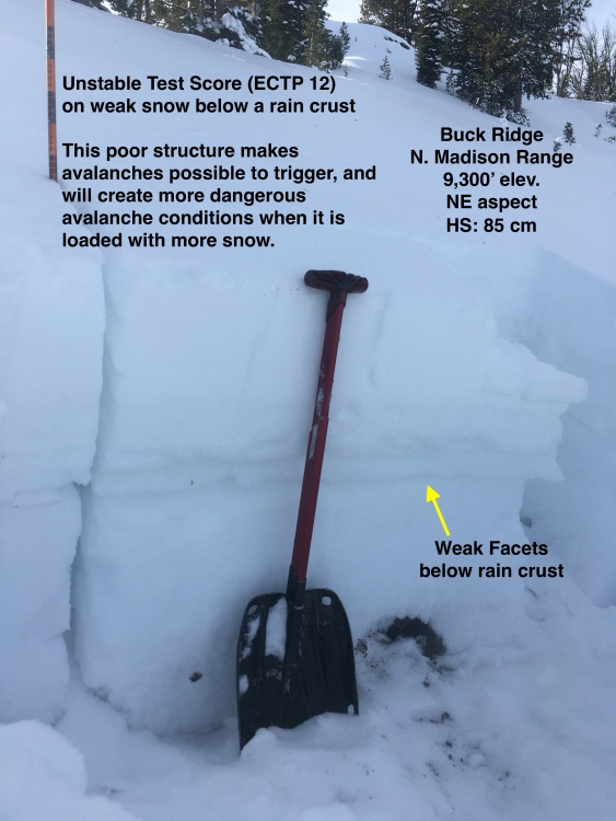
The mountains near Big Sky and the Taylor Fork have a weak, sugary layer of facets at the base of the snowpack (photo, photo, video). This snow structure is similar to the mountains near West Yellowstone, but half as much new snow is expected near Big Sky and Taylor Fork. Today new snow and strong wind will increase the avalanche danger and make avalanches easy to trigger. Avalanches breaking on sugary, weak snow can be triggered from lower angle terrain below steep slopes. Natural avalanches are possible on wind loaded slopes as they are loaded through today. Avalanche danger is CONSIDERABLE.
The mountains near Cooke City have a snowpack that lacks widespread buried weak layers. Avalanches will mostly break directly below the new snow from last night and today, which will total over a foot of snow equal to at least 1” of snow water equivalent. Danger will increase through the day, and avalanches will be largest and easy to trigger where strong winds drift new snow into thick slabs. Avoid steep wind-loaded slopes. Practice cautious route finding and conservative terrain selection. Avalanche danger is CONSIDERABLE.

In the Bridger Range and Hyalite avalanches will break on the interface below the new snow, mainly where it is drifted into fresh slabs. Expect avalanches to become larger and easier to trigger as snow piles up through today. Carefully assess the stability of the new snow before riding in steep terrain.
On Tuesday and Thursday, Bridger Bowl Ski Patrol triggered hard slab avalanches that broke on a thin layer of facets (photo, video). You can trigger similar slides today on heavily wind-loaded slopes near the ridgeline, such as the upper third of Saddle Peak. Today the avalanche danger is MODERATE.
If you get out, please send us your observations no matter how brief. You can fill out an observation form, email us (mtavalanche@gmail.com), leave a VM at 406-587-6984, or Instagram (#gnfacobs).
Backcountry Barriers Contest
Click here to learn more about the Backcountry Barriers Contest: 1.shortstack.com/NLfNvh
We recognize that backcountry skiing can be daunting. That’s why Ben Goertzen and the Friends of the Gallatin National Forest Avalanche Center have teamed up to help breakdown some of the most prominent barriers of entry to backcountry skiing through this campaign. One lucky winner will be given a complete backcountry skiing kit, a spot in an avalanche awareness course, and featured in a three part video series that ends with an excursion into the backcountry with professional skier and filmmaker, Ben Goertzen. These videos will be used by the Friends of GNFAC to help other aspiring backcountry skiers gain awareness, knowledge and start to breakdown their barriers to entry.
Upcoming Avalanche Education and Events
Our education calendar is full of awareness lectures and field courses. Check it out and plan to attend one or two: Events and Education Calendar.
BOZEMAN
December 11, 1-hr Avalanche Awareness, 6-7 p.m. at REI.
December 12, Avalanche Awareness + Beacon Practice, 6-8 p.m. at Story Mill Community Center.
WEST YELLOWSTONE
9 & 10 December, Snowmobile/Ski Introduction to Avalanche w/ Field Course, 12-5p Dec 9 and field day Dec 10. More info and Register Here.
MANHATTAN
December 9, 1-hr Avalanche Awareness, 7-8 p.m. at Manhattan High School.
COOKE CITY
Every Friday and Saturday, Snowpack Update and Rescue Training. Friday, 6:30-7:30 p.m. at the Soda Butte Lodge. Saturday anytime between 10-2 @ Round Lake.
The Gallatin Valley Snowmobile Association deserves a shout-out for putting up new beacon checkers at Taylor Fork and Buck Ridge Trailheads.