Good Morning. This is Eric Knoff with the Gallatin National Forest Avalanche Advisory issued on Saturday, December 9th at 6:45 a.m. Today’s advisory is sponsored by Cooke City Motorsports and Gallatin County Search and Rescue. This advisory does not apply to operating ski areas.
A stagnant weather pattern is creating strong temperature inversions. This morning, valley temperatures are 10-20 degrees colder than the mountains. A 5 a.m. mountain temps range from the mid-20’s to low 30’s F under clear skies. Winds are blowing 10-25 mph out of the W-NW with ridgetop gusts pushing 30 mph. Today, high pressure remains parked over the area producing sunny skies and relatively calm conditions. This calm and clear weather pattern will exist through the weekend.

Strong downslope winds continue to produce unusual loading patterns in the Bridge Range. Yesterday, the Bridger Bowl Ski Patrol closed sections of the Ridge due to heavy wind loading in mid-elevation terrain. Today, snow transport should be limited, but slabs that formed over the past few days will be scattered throughout the range. These slabs should be stiff and stubborn, but they could still fail under the weight of a skier or rider. Watch for and avoid thick wind drifts on the leeward side of ridgelines, gullies and cross loaded terrain features.
Today, heightened avalanche conditions exist on wind loaded slopes which have a MODERATE avalanche danger. Non-wind loaded slopes have a LOW avalanche danger.

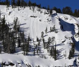
Today, there isn’t much new to report. Without a recent loading event, our generally stable snowpack remains in good shape. Yesterday, Alex ventured into Beehive Basin near Big Sky and found stable snow in his snowpits (video). He did observe a few wet loose slides on south facing slopes, but these were small and posed little threat. This is consistent with observations from Hyalite and the Cooke City area (photo, photo, video).
Aside from small wet loose slides and isolated wind slabs, there isn’t much in the way of avalanche hazard. Although conditions are generally stable, now is no time to become complacent. It’s important to remember that avalanches can still happen and even small slides can have severe consequences.
Today, a stable snowpack combined with stable weather will create generally safe avalanche conditions. For this reason the avalanche danger is rated LOW.
If you get out and have any avalanche or snowpack observations to share, drop a line via our website, email (mtavalanche@gmail.com), phone (406-587-6984), or Instagram (#gnfacobs).
Upcoming Avalanche Education and Events
BOZEMAN
Dec. 13, Avalanche Awareness, 6:30-8 p.m. at Gallatin Valley Snowmobile Association, 4-Corners
Jan. 12 and 13, Companion Rescue Clinic, Info and Register
Jan. 17, 18 and 20 or 21, Introduction to Avalanches w/ Field Day, Info and Register Here
Jan. 24, 25 and 27, Advanced Avalanche Workshop w. Field Day, Info and Register Here
Feb. 9 and 10, Companion Rescue Clinic, Info and Register
WEST YELLOWSTONE
Dec. 14 and 15, Snowmobiler Introduction to Avalanches with Field Course, Info and Register Here
COOKE CITY
8 and 9 December, Current Conditions and Avalanche Rescue, 6:30-7:30 p.m. Friday @ the Super 8, and anytime between 10-2 on Saturday @ Lulu Pass road.
The Last Word:
Check out this 2-minute video on the snowpack. Great graphics illustrate the process of sintering and faceting. Thanks to SINTR Visual Communications!