Good Morning. This is Eric Knoff with the Gallatin National Forest Avalanche Advisory issued on Saturday, December 11, at 7:30 a.m. Java Man, in cooperation with the Friends of the Avalanche Center, sponsors today’s advisory. This advisory does not apply to operating ski areas.
In the past 24 hours 3-4 inches of high density snow has fallen in the mountains around Cooke City and in the Bridger Range totaling a half inch of water (SWE). The rest of our advisory area picked up 2-3 inches. Currently, winds are blowing 15-20 mph out of the W-NW with gusts reaching the upper 30’s mph and mountain temperatures are between 10-15 degrees F. Today, temperatures will rise into the 20’s F under mostly clear skies, but increasing clouds and wind move into southwest Montana by this evening. Another storm system is scheduled to impact our area starting tonight and last through mid-day tomorrow. Accumulations of 2-4 inches can be expected in the mountains by tomorrow afternoon.
The Bridger, Gallatin and Madison Ranges, the Lionhead area near West Yellowstone, the mountains around Cooke City and the Washburn Range:
High Pressure during the earlier part of this week developed a variety of weak surface layers that have been capped by fresh snow and wind slabs. Although warm temperatures and strong winds over the past few days have worked these layers in many areas, I suspect pockets of surface hoar and near surface facets have been preserved. These layers will be most problematic in areas that have received recent wind loading.
The main concern today is any area with wind-blown snow which may rest on surface hoar and/or near-surface facets. Wind loaded areas near exposed ridgelines will be the most likely spot to trigger a slide, but watch out for cross loaded slopes at lower elevations. On Thursday the Moonlight Basin Ski Patrol Triggered a slide in the Headwaters area that broke up to three feet deep, reminding us that deeper instabilities are still lingering (photo). Areas where the snowpack is thinner, mainly near rock outcroppings and convex rollovers will be the most likely zones to impact these deeper weak layers.
Yesterday, I skied in the Bridger Range; both on the east and west side of the ridge, and found the weakest snow on SW facing slopes (photo). This shallow snowpack lacks structure and will struggle to support any load over an inch of water. Until we get more snow, this snowpack remains weak but not unstable. I did find remnants of surface hoar on NW facing slopes, but it did not appear to be well preserved.
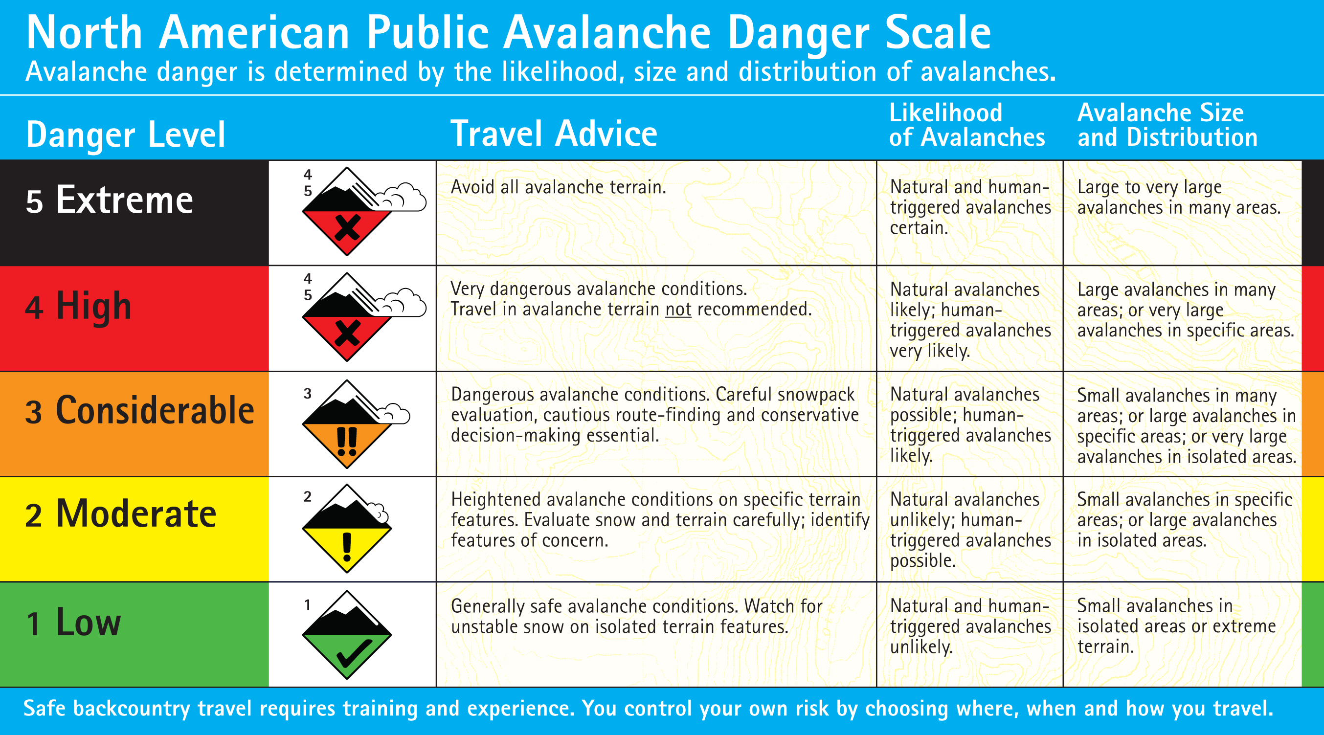
Today human triggered avalanche are possible and the avalanche danger is rated MODERATE. It’s important to remember a moderate danger warrants caution and should not be viewed as low. A revised version of the North American Public Danger Scale has been released and should be viewed for a comprehensive understanding of the danger ratings.
I will issue the next advisory tomorrow morning at 7:30 a.m. If you have any snowpack or avalanche observations, drop us a line at mtavalanche@gmail.com or call us at 587-6984.
Upcoming Avalanche Education
“How Much Did It Snow?” Join Lucas Zukiewicz from the Montana Snow Survey for a FREE presentation/discussion on the SNOTEL system in SW Montana. The discussion will cover how to access SNOTEL information and interpret the data for snow and weather conditions. Tomorrow - Saturday, December 11, 7:30pm – 8:30pm at World Boards.
Avalanche Awareness for Snowmobilers in West Yellowstone Thursday, December 16th from 12 p.m. to 5 p.m (lectures), with an all day field day Friday, December 17th. For more information check out http://www.mtavalanche.com/education/classes/snowmobilers or call us at 587-6984.
1hr Awareness - Mon, December 13, 7pm – 8pm at Beall Park map
Other News
This year REI has chosen Friends of GNFAC as their charity of choice. By making a donation through REI you can help The Friends continue to support the Avalanche Center and promote avalanche education throughout southwest MT.