Good morning. This is Dave Zinn with the Gallatin National Forest Avalanche Forecast on Tuesday, April 5th at 7:00 a.m. This information is sponsored by Spark R&D and Uphill Pursuits. This forecast does not apply to operating ski areas.
This morning, temperatures are in the single digits to mid teens F with 25-35 mph winds from the west. The mountains around Cooke City received 13” of new snow with 8-11” south of Bozeman and near Big Sky and 3-5” near West Yellowstone and in the Bridger Range. Today, temperatures will be in the 20s F with 25-40 mph winds from the west. The mountains around Cooke City will get another 2-4” of snow by morning with a trace to 1” near Bozeman, Big Sky and West Yellowstone.

Very dangerous avalanche conditions exist in the mountains around Cooke City, where strong winds gusting to 60 mph are drifting 13” of new snow equal to 1.3” of snow water equivalent (SWE) into thick slabs that will avalanche on steep slopes. Large avalanches are likely and slides breaking on weak layers buried 2-3’ deep are possible. Today, snowfall and strong winds will continue to load slopes. Avoid all steep, wind-loaded slopes and the areas immediately below because human-triggered avalanches are very likely.
The avalanche danger is HIGH on wind-loaded slopes and CONSIDERABLE on all others. In non-wind-loaded terrain, cautious route-finding, conservative decision-making and careful snowpack evaluation are essential.

Dangerous avalanche conditions exist in the Northern Madison and Northern Gallatin Range, where strong winds are drifting 8-10” of new snow (0.8-1.0” of SWE) into unstable slabs on steep slopes. Winds are gusting 60-80 mph and will affect the snow at all elevations and aspects, expect to see different loading patterns than you are used to. Human-triggered avalanches are likely on wind-loaded slopes and could be large, especially in alpine terrain exposed to more wind. Slides failing on weak facets buried 18-30” deep are possible on isolated slopes (Flanders video). Signs of instability such as recent avalanches, shooting cracks or collapsing tell you to select lower angle riding or skiing.
The danger is CONSIDERABLE on wind-loaded slopes and MODERATE on all others.
Our accident report from the Wilson Peak avalanche on April 2nd is complete and available HERE.

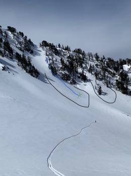
Human-triggered avalanches are possible in the Southern Madison, Southern Gallatin and Bridger Ranges and in the mountains around West Yellowstone, where strong winds are drifting 3-5” of new snow (0.3-0.5” SWE). Despite the lower snow totals, avalanches could be large in alpine terrain exposed to more wind and on isolated slopes with weak layers buried 1-2’ deep. A skier was injured and evacuated by Gallatin County Sheriff Search and Rescue two days ago when a pair triggered a small avalanche on a wind-loaded slope north of Big Sky (photos and details). This is a good reminder that even relatively small avalanches are consequential when terrain traps such as trees or cliffs are present.
The danger is MODERATE on wind-loaded slopes and LOW on non-wind-loaded slopes. Retreat to terrain unaffected by the wind if you observe signs of drifting or instability.
If you get out, please send us your observations no matter how brief. You can submit them via our website, email (mtavalanche@gmail.com), phone (406-587-6984), or Instagram (#gnfacobs).
Hyalite Canyon Road is now closed to vehicle traffic for the spring thaw and will reopen on May 16th.