Good morning. This is Dave Zinn with the Gallatin National Forest Avalanche Forecast on Tuesday, March 22nd at 7:00 a.m. This information is sponsored by Gallatin County Sheriff Search and Rescue and Mystery Ranch. This forecast does not apply to operating ski areas.
This morning, temperatures are in the teens F with 5-20 mph winds from the west to northwest. The Bridger Range received a trace of new snow overnight. Today, highs will be in the 30s F with 5-15 mph winds from the west to northwest and skies will clear. The next chance for significant precipitation is early next week.

All Regions
It is possible to trigger an avalanche on steep slopes across the advisory area today. This weekend 2-10” of snow fell favoring the mountains around Bozeman and Big Sky. Slopes with recent drifts of wind-loaded snow are the most likely place to trigger an avalanche. These could break 1-2’ deep and 100’+ across. While the northern portions of the advisory area got the most snow this weekend, the story is fundamentally the same in the southern ranges.
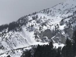
Yesterday, skiers triggered avalanches both north and south of the Bridger Bowl Ski Area boundaries and were thankfully able to ride out of the slides (Saddle Peak photo and details, north of boundary details). And, a sledder rode away after triggering an avalanche on Cedar Mountain (photo and details). Sunday night, many new snow avalanches ran in the Divide Peak Cirque in Hyalite Canyon (details) and a large avalanche broke under cliffs on a wind-loaded slope on Cedar Mountain (photo and details). On Saturday, Ian and Alex saw two avalanches triggered by cornice fall in the Lionhead area (video, photos and details) and skiers in the Republic Creek drainage near Cooke City saw a similar slide (photo and details). Touring in the Bridger Range on Sunday, Doug warned us in his video that in higher elevations where the winds are blowing, he expected to see more avalanches.
Temperatures will warm above freezing under clearing skies today. This afternoon, unconsolidated snow in the upper snowpack on south-facing slopes and at lower elevations will get wet, lose strength and become more likely to avalanche. Shift to slopes where the snow surface is cooler and consider the terrain you will need to return through on your way home.
A weak layer of facets is buried 1-3’ deep on many slopes that could allow slides to initiate more deeply and propagate across wider areas. These avalanches are less likely but more dangerous. Skiers in Bear Basin this weekend heard a loud “whumph” when they collapsed these weak layers (details). I investigated a skier-triggered avalanche that broke 18” deep and 500’ wide in Wyoming Bowl on weak faceted snow a week ago (video and details).
Today, evaluate the snowpack and terrain carefully. Be skeptical of stability in recently wind-loaded terrain and on steep south-facing slopes prone to warming in the afternoon. The danger is MODERATE.
If you get out, please send us your observations no matter how brief. You can submit them via our website, email (mtavalanche@gmail.com), phone (406-587-6984), or Instagram (#gnfacobs).
On March 19, two skiers were caught and one was killed in an avalanche near Steamboat Springs, Colorado (preliminary details). This was the fourth avalanche fatality in the U.S. in the past week and the fifteenth this season (https://avalanche.org/avalanche-accidents/).