Good Morning. This is Dave Zinn with the Gallatin National Forest Avalanche Forecast on Wednesday, January 20th at 7:30 a.m. Today’s forecast is dedicated to Tyler Stetson. Tyler was killed in an avalanche in Beehive Basin on this day thirteen years ago. This forecast does not apply to operating ski areas.
There was no new snow in the last 24-hours, temperatures are in the single digits to 20 F and the wind is blowing 15-25 mph from the southwest to northwest. Skies today will be partly cloudy, temperatures will be in the 20s F, and the wind will be 15-25 mph from the west to southwest. The next snowstorm arrives tonight and there will be a trace to 1” of snow by morning.

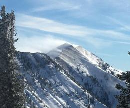
Winds increased yesterday afternoon in the Bridger, Northern Gallatin and Northern Madison Ranges transporting the recent snow, creating unstable drifts and adding stress to persistent weak layers. Yesterday, skiers near Mount Blackmore observed avalanches on the north and east faces, leading them to return to the lower angle terrain near their skin track (details and photos). Fresh drifts drove a team of ice climbers to turn back before reaching their objective in Hyalite Canyon. Representing many of the taller mountains in these ranges, Saddle Peak, immediately south of Bridger Bowl received a heavy load of wind-drifted snow throughout the day (photo). Sugary snow near the ground is becoming harder to trigger, but the resulting avalanches will be larger and more dangerous (2020-21 videos). A recently buried layer surface hoar exists about a foot deep, although more variable in its distribution, assume that it is everywhere as Doug explains from Mount Blackmore (video).
Today, avoid wind-loaded slopes and the terrain below them as human-triggered avalanches are likely and the danger is rated CONSIDERABLE. Human-triggered avalanches are possible on non-wind-loaded and the danger is MODERATE.

The wind has eased off in Cooke City but not before transporting this week’s snow and creating unstable drifts that avalanched yesterday on a layer of weak snow buried 1’ deep. Riders in Sheep Creek triggered a slide and witnessed two others, thankfully, no one was buried or injured (details). A skier near Goose Lake observed two small, slab avalanches one triggered by a rider and another by a skier (details and photo). Concern about larger avalanches led the skier to back off their objective. Recent and drifted snow is sitting on a weak layer of surface hoar now buried one foot deep and a layer of weak facets buried 3’ deep. Neither of these layers is everywhere. In my videos from Cooke City earlier this week I recommend assuming they are universal in their distribution or thoroughly assess the snowpack (video, video).
Avalanches will not be as sensitive to triggers today but they remain possible. Remain cautious especially on wind-drifted slopes. The danger is rated MODERATE.
The Southern Gallatin, Southern Madison and Lionhead Ranges received less new snow and less wind this week but have the same weak foundation. We have minimal trust in the snowpack structure and are managing the problem by avoiding steep terrain. Watch any of our videos from this season and notice this theme. Large, human-triggered avalanches failing on a recently buried surface hoar layer or deeper on sugary facets near the ground are possible today and the danger is rated MODERATE. Make conservative terrain choices due to the involvement of persistent weak layers.
If you get out, please send us your observations no matter how brief. You can submit them via our website, email (mtavalanche@gmail.com), phone (406-587-6984), or Instagram (#gnfacobs).
Upcoming Avalanche Education and Events
See our education calendar for an up-to-date list of all local classes. Here are a few select upcoming events and opportunities to check out:
Every Saturday in Cooke City, FREE snowpack update and rescue practice at the Round Lake Warming Hut between 10 a.m. and 3 p.m. Poster with More Info.
TONIGHT, January 20 & 21 (plus field sessions the following weekends), Avalanche Fundamentals with Field Course. There are separate field sessions tailored for both skiers and splitboarders (Bridger Bowl) and snowmobilers (Buck Ridge). Register here.
Ski-Doo is offering free avalanche education classes online that you can take here: https://www.ski-doo.com/avalanche.html