Advisory Archive
In the last 24 hours Hyalite and Big Sky picked up 5-6” of new snow with 3-4” falling in other areas. At 5 a.m. skies are cloudy and mountain temperatures are in the single digits to low teens. Ridgetop winds are blowing N-NW at 15-20 mph and gusting into the 40s around Cooke City. Snow showers this morning will drop another inch with temperatures climbing toward 20F and winds remaining NW at 20-30 mph.


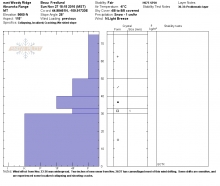
At 6 a.m. it’s snowing in the mountains. So far Big Sky and the Yellowstone Club have 7-10” with 5” outside West Yellowstone and 3” everywhere else. Mountain temperatures are in the low to mid-teens and winds are out of the southwest to northwest at 15-20 mph. Snowfall will continue and winds will increase today and tonight. By the time the storm will ends tomorrow I estimate another 10” will fall around Big Sky and 4” everywhere else.
At 5 a.m. there’s no new snow to report, just unseasonably warm temperatures and decreasing winds. Winds are west to southwest at 15-20 mph with gusts hitting 40 mph and mountain temperatures in the high 20s under clearing skies. Today will be sunny and unseasonably warm with higher elevations reaching 40F. Sunday will be mostly cloudy and colder with scattered snow showers that evening and Monday.
Check out our new button that displays the previous week’s weather and avalanche activity:
No new snow has fallen in the last 24 hours, but winds have increased. Yesterday winds blew out of the northwest in the Bridger Range and out of the southwest everywhere else. Speeds ranged from 20-25 mph with gusts of 30, except in the Hyalite area where gusts got close to 60 mph. Today skies will become mostly sunny in the afternoon as a ridge of high pressure builds. Temperatures will rise into the mid 30s from the low 20s overnight.
Check out our new button that displays the previous week’s weather and avalanche activity:
Finally, a taste of winter. Snowfall started yesterday afternoon and ended last night. The northern mountains got 6-8” as did Cooke City. The southern mountains and West Yellowstone picked up 4-5”. Winds have been blowing west to northwest at 15-20 mph with gusts of 35 and mountain temperatures are 10-15F. Skies are clearing as a ridge of high pressure moves in. Through Saturday the forecast calls for dry weather and mountain temperatures reaching above freezing. The good news is that unsettled weather is predicted early next week.
Check out our new button that displays the previous weeks weather and avalanche activity:
The unsettled pattern that dropped snow over southwest Montana has now pushed to the east. This has allowed a ridge of high pressure to build over the area. This ridge will remain stationary for much of the weekend producing sunny skies and warmer temperatures. Highs tomorrow (Saturday) will warm into the upper 30s to low 40s and winds will blow 5-10 mph out of the W-SW. The ridge gradually begins to break down Sunday, producing partly cloudy skies and stronger winds Sunday afternoon. There is a slight chance of rain and snow showers early next week.

Winter has made a welcome appearance. Snowfall totals over the past 48 hours are 6” near Bozeman and Big Sky, 14” near Cooke City, and 16” near West Yellowstone. Wind overnight was out of the northwest at 10-15 mph with gusts near 20 mph. Temperatures this morning are 10-20 F and will reach the mid-20s F today. Wind will be 5-15 mph out of the north to northeast today, and 1-2 more inches of snow will fall before the storm ends this afternoon.

At 0730 many weather stations are reporting fresh snow. The Bridger Range got dusted, the Hyalites are showing 3”, and the Yellowstone Club has 7” as does the southern Madison Range and higher elevations outside Cooke City. The mountains around West Yellowstone received a lot of water (1.5”), but above freezing temperatures kept snowfall amounts under a few inches. Mountain temperatures are near freezing and winds are southeast in the mountains around Bozeman and west to southwest at 20-25 mph everywhere else. The brunt of the storm has passed and drier air today and tomorrow morning will give way to wetter and cooler air Sunday evening.
A series of storms since last Friday delivered snowfall throughout the mountains of southwest Montana. Another 4 to 8 inches of snow fell last night, and there is 8 to 12 inches of dense snow on the ground throughout our advisory area. Wind has been out of the west to southwest at 15-25 mph for the past 24 hours, and temperatures this morning are in the mid-20s F. Temperatures will be in the 30s F today and rise to the upper 40s F through the weekend. Wind will remain westerly through the weekend at 10-20 mph with the exception of gusts near 30-40 mph late Thursday to early Friday. Expect showers today to taper off by this evening, and then a few brief showers Thursday and Friday night.

Last night it snowed. Searching online I’m unable to get detailed information as SNOTEL is not reporting and ski areas only have wind data. This morning I wandered out into my yard with a headlamp and measured 6” of snow on my picnic table with obvious wind drifting. I’m guessing that 12+” are in the mountains. Last night upper elevation temperatures dropped into the 20s with westerly winds of 20 mph before they swung east. Today will be cloudy with a few flurries and Wednesday and Thursday look sunny with temperatures rising into the 50s in town.