Advisory Archive
In the last 24 hours the mountains got one inch of new snow in the northern ranges with 2-3 inches falling down south. Wind speeds increased last night from the west to southwest averaging 30 mph with gusts reaching 64 mph in Hyalite. This morning, under partly cloudy skies, temperatures are in the high teens in the south and mid-20s in the north. Today will remain partly cloudy and windy with mountain temperatures rising into the upper 30s.


Winter stopped by for a visit and left a few goodies. Yesterday’s snowfall dropped 10 inches in the Bridger Range bringing their 36-hour storm total to 18 inches. Also 10 inches fell in the northern Gallatins, 6 to 10 inches fell around Big Sky and 2-4 inches fell in the southern mountains. West to southwest winds are averaging 20 mph with gusts to 30 mph under clearing skies. This morning temperatures are a chilly 5F to 10F, but should warm to the high 20s. Today will be partly cloudy and windy with more cloud cover rolling in tonight.
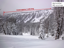
AVALANCHE WARNING
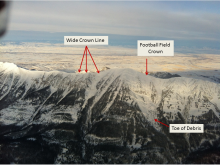
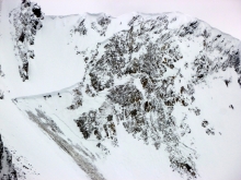
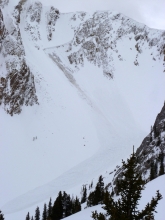
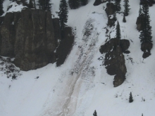
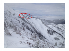
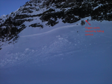
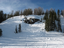
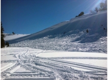
The Gallatin National Forest Avalanche Center is issuing a Backcountry Avalanche Warning for the southern Gallatin Range, southern Madison Range and Lionhead area near West Yellowstone. Heavy snowfall and strong winds are creating unstable conditions in the backcountry. Natural avalanches are currently large and destructive. The avalanche danger is rated HIGH on all slopes. Avalanche terrain including avalanche runout zones should be avoided.
Mountain Weather
Over the past 24 hours most areas picked up 4-6 inches of new snow with the exception of Cooke City which has picked 8 inches. Snow should continue through much of the day with an additional 4-6 inches falling by this evening. Currently, mountain temperatures are in the mid-teens to low twenties and winds are blowing predominately out of the west at 10-20 mph. Today, temperatures will warm into the high twenties to low thirties and winds will continue to blow out of the WNW at 10-20 mph. A ridge of high pressure will gradually build this evening and tomorrow looks to be a nice day.
Over the past 24 hours the mountains around West Yellowstone picked up 6-8 inches of high density snow; all other areas picked up 3-5 inches. Currently mountain temperatures are in the mid-twenties to low thirties and winds are blowing out of the SSW at 15-30 mph with gusts in Hyalite and Big Sky reaching close to 50 mph. Today, temperatures will warm into the mid to upper thirties and winds will continue to blow 15-30 mph out of the SSW. A moist southerly flow will produce a strong chance of mountain snow showers through the day. The southern mountains should pick up 4-6 inches by the tonight and 8-10 inches by tomorrow morning. The mountains around Bozeman and Big Sky will likely pick up 3-5 inches by tomorrow morning.
March Madness is here with more rain, snow, and above freezing temperatures. Yesterday most areas received a mix of rain and snow below 8000 ft and just snow above this elevation. The mountains near West Yellowstone and the Taylor Fork received 10 inches of heavy, dense snow, near Big Sky and Cooke City 3-5 inches, near Bozeman 2-3 inches. Temperatures this morning were hovering near freezing and winds were blowing 10-15 mph from the S with gusts of 25 mph. Hyalite was the exception with winds blowing 20-45 mph.
Today the madness continues. Temperatures should rise into the mid 30s F while some areas could see temperatures in the 40’s F. Winds will increase some but continue from the S. By tomorrow morning, another 10 inches of snow (1+ inches of SWE) will fall near West Yellowstone and the Taylor Fork, near Big Sky and Cooke City 4-6 inches of snow, and near Bozeman 2-3 inches of snow.

Yesterday’s weather had rain, sun, clouds, snow, and wind; everything but cold temperatures. Since yesterday morning areas near the Taylor Fork, West Yellowstone, and Cooke City received 0.2-0.4 inches of water in the form of rain in valleys and snow above about 7500 ft. This morning winds were blowing 20 mph from the S and SW with gusts of 40-50 mph. Temperatures did not cool overnight and this morning remained near freezing at ridgetops and in the high 30s F in mountain valleys.
Strong SW winds and above freezing temperatures will continue today. More precipitation will fall mostly near West Yellowstone where the mountains will receive 4-6 inches of snow by tomorrow morning. The mountains near Cooke City will receive 2-4 inches and the rest of the area will receive 1-3 inches.

Since yesterday 5-8 inches of snow (0.8-1.0 inches of SWE) fell in the southern Madison Range and in the mountains near West Yellowstone and Cooke City. 3-5 inches fell in the Bridger Range and mountains near Big Sky (0.3-0.5 inches of SWE), and the Hyalite Canyon area received 1 inch. This morning winds were averaging about 20 mph from the SW gusting to 35 mph. Temperatures were near 32 degrees F.
Today will be warm and windy again. Temperatures in the mountains near Bozeman will be in the 40s F while other areas will have temperatures in the 30s F. Winds will continue from the SW blowing 20-30 mph and increase by this afternoon with gusts of 50 mph. The mountains near West Yellowstone and Cooke City should receive another 2-4 inches while other areas will get a dusting of snow or a sprinkle of rain.
Yesterday was windy at all elevations with southwest winds hitting 93 mph on Lone Mountain. Winds died down last night before the snowfall started. As of 6 a.m. the Bridger Range and mountains around Big Sky have six inches of snow while the southern Madison Range and mountains around West Yellowstone and Cooke City got 2-3 inches. Temperatures dropped into the mid-20s last night and winds are now WSW at 20-40 mph. Today, temperature and winds will not change much. A moist southwest flow will bring mostly cloudy skies and sporadic snowfall through tonight. By morning I expect 2-4 inches.


Warm and windy describe this morning’s weather. Mountain temperatures are near 30F under partly cloudy skies as west to southwest winds average 25-30 mph and gusts to 70 mph at the Yellowstone Club. Clouds will increase as a cold front moves in from the southwest. Winds will get even stronger as the front passes later today. Temperatures will drop into the low 20s and by morning the southern mountains will get 2-4 inches of snow with the northern ranges getting 1-2 inches.
Since early this morning a fast moving storm has dropped nine inches of snow in the Bridger Range, 2-3 inches in the northern Madison and Northern Gallatin Ranges and a trace to one inch elsewhere. Currently, mountain temperatures are in the teens around Big Sky and low to mid-twenties over the rest of our advisory area. Winds are blowing 15-30 mph out of the WSW with gusts reaching close to 40 mph. Today, temperatures will warm into the high 20s to low 30s F and winds will continue to blow 25-35 mph out of the WSW. Snow will end late this morning but skies will remain mostly cloudy through the day. A warm and dry pattern will settle in this afternoon and remain in place through tomorrow.