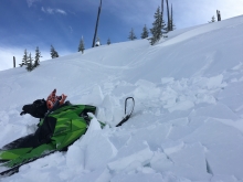
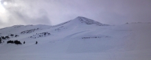
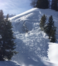
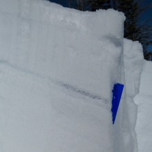
Advisory Archive
The mountains near Bozeman and Cooke City got around 2” of snow since yesterday, while the rest of the area remained dry. Winds have been westerly at 15-20 mph with gusts near 40 mph. Temperatures this morning are in the high teens to low 20s F and will be in the high 30s F today. Wind will be light today, around 5-15 mph out of the west-southwest, and skies will be mostly clear. The next chance for snowfall is Sunday.


The mountains received around 1” of snow in the last 24 hours. Winds overnight were out of the west-southwest with average speeds of 5-10 mph and 20 mph near ridgetops with gusts in the 30s. Temperatures are in the mid-20s F this morning and will rise to high 30s today under mostly cloudy skies. Wind will remain out of the west-southwest with speeds up to 35 mph. Snow showers are expected this afternoon with 1-2” of snow by tomorrow.
At 6 a.m. snowfall is measuring 4 inches outside Cooke City, 2-3 inches around Taylor Fork and West Yellowstone and 1-2 inches everywhere else. Winds are strong from the west to southwest with gusts of 60 mph and average speeds of 20-30 mph. Under cloudy skies mountain temperatures are in the mid-20s. Winds will remain strong and another 1-2 inches will fall in the south this morning. Skies will be mostly cloudy and temperatures will reach the low 30s.


There’s been no new snow in the last 24 hours, but gusty winds yesterday morning topped 60 mph at the ridgetops. This morning, west winds are averaging 20 to 30 mpg under clear skies with mountain temperatures of 10F. Clouds will increase today and temperatures will warm into the 30s. Tonight winds will increase from the southwest at 20-40 mph and 1-2 inches of snow is expected by morning.
Overnight the mountains picked up 2-4 inches of high density snow. At 5 a.m. it’s still snowing lightly and temperatures are in the mid-teens to low 20s F. Winds are strong out of the west blowing 15-25 mph with gusts near 40 mph. Snow will taper off this morning as a weak ridge of high pressure builds over the area. Skies will start out partly cloudy, but will become mostly clear by this afternoon. Temperatures will warm into the upper 20s to low 30s F. West winds will remain strong this morning, but will gradually decrease throughout the day. No new snow is expected tonight or tomorrow.
Over the past 24 hours the mountains south of Bozeman picked up 2-4 inches of snow while the Bridger Range picked up about an inch. At 5 a.m. snow has stopped falling and temperatures are in the upper teens to mid-20s F under partly cloudy skies. West winds are blowing 10-20 mph with a few ridgetop gusts hitting 30 mph. Today, temperatures will warm into the upper 20s to low 30s F and winds will remain moderate to strong out of the west. Skies will start out partly cloudy this morning and become mostly cloudy by this afternoon. Another storm system moves into the area tonight and tomorrow delivering widespread precipitation. The mountains should see 1-2 inches tonight with another 1-2 inches falling during the day tomorrow. This storm will favor the mountains south of Bozeman.
This morning temperatures are in the upper 20s to low 30s F and winds are blowing 15-30 mph out of the W-SW with gusts around Hyalite and Big Sky breaking 40 mph. Today, gusty conditions will continue as a storm system moves into the area. Winds will continue to blow 15-30 mph out of the W-SW with stronger ridgetop gusts likey. Temperatures will remain warm with highs climbing into the mid to upper 30s F. Snow will develop over the mountains by late morning/early afternoon and will continue through the evening hours. By tomorrow morning, the mountains around Bozeman will likely see 2-4 inches while the southern mountains including Big Sky will pick up 3-5 inches.

At 4 a.m. mountain temperatures are in the 20s F and rising. Wind overnight was out of the west-southwest at 5-15 mph with gusts in the 20s. Today will be mostly clear with temperatures in the 30s to low 40s F. Wind will remain out of the west-southwest at 10-15 mph today, and then increase overnight to around 30 mph by morning. Expect a few inches of snow Saturday afternoon with more Sunday night.


This morning, skies are partly cloudy with mountain temperatures in the high teens to low 20s F. Winds overnight have been westerly at 5-15 mph with gusts in the 20s. Today will be sunny with temperatures in the high 20s to low 30s F and wind out of the west at 15-20 mph. This mild, dry weather pattern will persist through Friday and there is a chance for snow Saturday morning.
At 5 a.m. skies are clear, mountain temperatures are in the low teens and winds are from the west at 15 mph. This morning will be mostly sunny with light west winds and temperatures reaching the mid-30s. This afternoon high clouds coupled with a light breeze will keep snow surface temperatures cool enough to ward off wet avalanches. Tonight will be mostly clear and temperatures will dip into the teens as the high pressure continues.