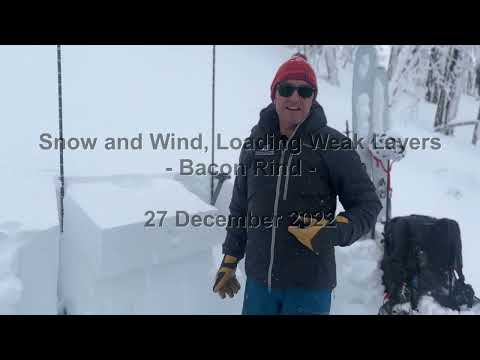
Snow Observations List
Pit Location: E / ESE Aspect | 10,000' | 220 - 230 cm snow depth | Near Treeline | 28 degree slope
Weather at 14:15: OVC | S1 | Winds Strong out of the S / SSW
Test Results:
16cm down from surface; ECTN2 PC and ECTN3 PC at the newer snow interface, still a fairly soft slab without a lot of cohesion in this particular area
71cm down from surface; ECTP21 SP and ECTP23 SP, broke on the same layer of small facets (~0.5-1.0mm) noted in 12/27 forecast below this week's more recent storm snow
Mostly minor cracking observed at the snow surface during today's outing, a couple of shooting cracks were observed in steeper wind drifted snow in more exposed areas
Full Snow Observation ReportDug and skied in a protected, treed little bowl I visit at 9500 ft. with a general ENE aspect. The approach is on a solar aspect with minor avalanche terrain between 8-9K. The quick n dirty pit was about 130 cm, ENE, 9300ft., just off ridge top. Bottom half was faceted, 2mm generally, but surprisingly tightly packed together. Hardness of 1F in much of the faceted section, with a couple of layers of 4F. Upper half of the pack was generally rounds until near the surface where it was a bit more faceted. We got a CT6 Q2 on a wind slab interfaced with other wind slabs about 30 cm's down. The deeper pack did not fail in CT. The unstable result near the surface did not scare me particularly due to the nature of the terrain, isolated nature of the wind slab confined to the very top of the ridge, ability to safely cut entrances to runs, relatively thick timber, etc. We skied dense powder with no signs of instability beyond the snowpit; all about terrain choice yesterday (every day?).
Full Snow Observation ReportWe parked at the bridge and headed up from there. We dug our first pit on a south facing mid-elevation hill. There was 75 cm of snow (HS) a 5 cm thick faceted layer 1 foot deep, then solid snow to the ground. The facets are the same we are finding elsewhere and I got a CT0, which denotes instability. We went to the upper meadow and dug 2 pits (125 and 100 cm HS) but this same faceted layer was thin and not reactive. Neither were the facets in the lower third of the pit. We went to the Skillet and dug there. Again the upper faceted layer was thin and not an issue. The CT0 has me concerned and I am ruling the ECTNs as being irrelevant.
Full Snow Observation Report

We dug in the first yellow mule, NE aspect at 9,400'. HS was 128cm and we had two ECTX. We identified the two weak layers we have been talking about in forecasts (see video), but they were not reactive here in our tests. We dug in the second yellow mule, NE aspect 9,300' and HS was 93 cm. Here we had ECTP26 on the layer of facets near the bottom of the snowpack. In both pits and a quick pit in 3rd yellow mule there was a stout ice crust (maybe a rain/mist crust) about 10cm down that is not a problem at the moment, but notable due to being widespread and unusual for our normally dry snowpack (see picture).
We saw two large avalanches in the 2nd Yellow Mule that were probably 2-3 days old, and likely broke on the weak layer near the bottom of the snowpack. Hard slabs on heavily wind-loaded slopes.
Full Snow Observation Report


Pit Location: E / ESE Aspect | 8900' | 150 - 160 cm snow depth | Near Treeline | 29 degree slope
Weather at 15:20: OVC | S-1 to S1 | Winds Strong out of the WSW / SW
Test Results:
14cm down from surface; CT1 (2x) at the new snow interface, fairly soft slab without a lot of cohesion in this particular spot NTL
43cm down from surface; CT11 SP and CT17 SP, broke on a layer of small facets (~0.5-1.0mm) below this week's more recent storm snow
Did not have time to do a full ECT, however the interface was very planar and yielded a sudden collapse at the layer in question
Full Snow Observation ReportWe found the recently buried weak layer of near-surface facets one foot deep. The sugary facets lower in the snowpack were also present but neither propagated in our stability tests. Thankfully, another group dug a pit nearby. They got an ECTP20 on the near-surface facet layer one foot down. This means the layer is confirmed in Hyalite, Buck Ridge, and Lionhead. A similar story is coming out of the Bridger Range. Until proven otherwise, I am operating with the assumption that it is everywhere from north of Bozeman to Island Park. I am worried about this layer when more snow starts adding up.
The wind was blowing ~ 20 mph on the ridge and depositions of wind-drifted snow near ridgelines, in cross-loaded gullies and near wind-breaks like trees, cliffs, and outcroppings were the most likely place to trigger a slide today.
Temperatures were above freezing when we got back to the car. Some small, wet-loose snow avalanches slide from road cuts and piled up a few feet deep next to the Hyalite Canyon Road.
Full Snow Observation Report


From email: "Skied NW of Cooke City today.
Yesterday the temps got up to 35 deg F at the NE Entrance SNOTEL. (It was raining hard and in the low 40's F yesterday between Laurel and Big Timber on I90.)
It didn't appear that it rained here, but there was upside-down trail breaking in the lower elevations today and hazardous conditions around 8700' as the slab got thicker. The cold temps of last week definitely weakened/ faceted the snow in the thinner snowpack areas. Photos attached of some cracking and a D1 soft slab that I remotely triggered with an intentional ski cut. The slab was about 6"-1.5' deep and about 50' wide. It was a SE aspect around 8700.
Above 9k', the snow structure was looking a lot better, and I was getting ECTNs (snowpit attached), and no more collapsing nor cracking. The trees are CAKED with snow above 9k' in wind-sheltered areas."
Full Snow Observation Report


location:
Northern Madison Range
9,400 ft (below ridge top leeward and trees)
130° SE aspect
110cm Depth of Snow
24° slope
CT 12
ECTN 11 @ 20cm down
Widespread collapsing.
Terrain choices: very simple


Toured up to Texas Meadows yesterday, it was spring-like conditions the whole way. We dug a pit at approximately 7600ft on an east aspect, HS was 114cm, and we got an ECTx. There was 10 to 20cm of weak rounds on the ground, and a layer of weaker snow at about 67cm. Our shovel shear broke on the 67cm layer, but it wasn't planar.
Full Snow Observation ReportWe went for a short tour this morning in Beehive Basin up to Prayer Flags. We found about 2 inches of dense snow that did not appear to have been transported by the wind. Beehive peak was painted white by the dense snow that stuck to it. We found good skiing conditions on our first run into Middle Basin. On our way back up, the sun came out and the snow surface started to rapidly warm on any aspect the sun touched. Snow bombs fell from trees, skins glopped, and we noticed pinwheels and small point releases around rocks. At that point the skiing began to deteriorate and we decided to call it a day early around 11 AM. On our final run back to the car we saw a sluff in the going home gully on a west aspect around 9,000’ that ran into another party’s old tracks (photo included).
Full Snow Observation Report

36” total. 24” sugar on bottom.
From Email: It was actually great riding up there. Just no base once you broke through. Definitely solid on top and held weight of the sled.
Full Snow Observation Report

Rode Buck today, found a substantial ice crust at all elevations and aspects just under last nights 2-4” of snow. Must have rained a little? 1/8-1/4” thick in places, was quite surprised. Found some decent pockets of snow but overall quite variable conditions and not great riding compared to how it’s been the last few weeks.
2’ Deep facets at the ground are beginning to round and become more cohesive. Another weak layer below the ice crust 8-10” from surface seemed quite reactive in quick hand pits but could not trigger it riding and saw no natural releases. Both the two near surface weak layers could be problematic with a slab on them. Something to keep an eye on moving forward.
Full Snow Observation ReportWe rode back to the top of Ski Hill in soupy fog. We walked down to the pit site and were not sinking to the ground…a bit of a surprise. The pit was 137cm deep and the facets in the lower half are not an issue. We identified a weakness 1 foot under the surface and it broke as ECTP10. Subsequent hits yielded no results. The weak layer is facets (sugary) 5cm thick that likely formed during the clear spell in the last week or so. This was our primary concern. We were both shocked at how deep Ski Hill was fo this time of year and we did not expect to find this weak layer.
Full Snow Observation Report


Went up Wheeler this afternoon and found general stability. Dug a couple of pits around on E and SE aspects at around 6800ft, ECTx in both, about 20 to 30cm of weaker snow on the ground, but it was less faceted than expected given the cold snap recently. Pole probed and dug down by hand at about 8400ft and found a very similar structure.
Full Snow Observation ReportWe rode from Taylor Fork TH to Carrot Basin. We dug at the wilderness boundary on a SW aspect at 8,800’. HS was 130 cm (~4 feet) with 2x ECTX. We found facets from 100 cm all the way to the ground. However, facets were not our biggest concern today. The wind has drifted 12” of new snow throughout Taylor Fork, and we were unable to see how much wind loading was done on steeper slopes nearby. Low visibility caused by new snow and wind kept us out of avalanche terrain today. Over the next few days in this area, steep, wind loaded slopes should be carefully assessed with an ECT, and riders should watch for cracking and collapsing in the wind drifted snow.
Full Snow Observation Report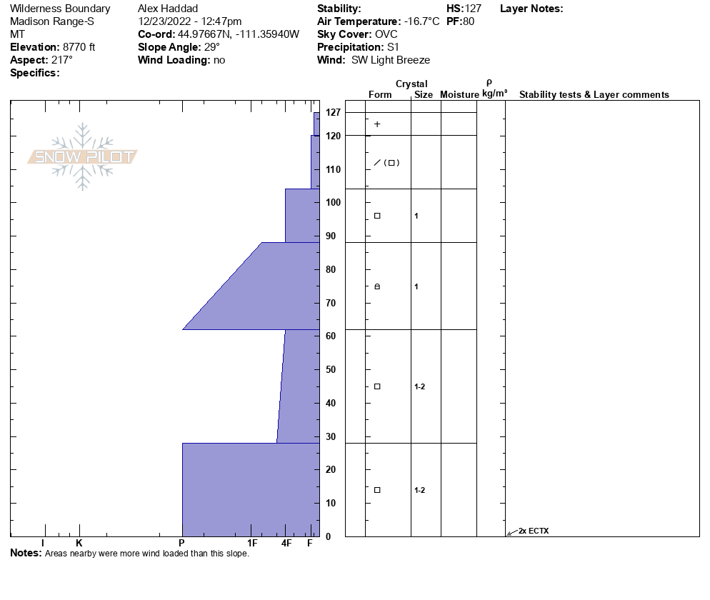
Snowpack at 8000 ft in pioneers is about 2 feet deep and mostly facets. About a foot of 3 mm large squares on the ground, a slightly more dense 4F- layer of crust and facets and another foot on top of that of soft NSF and new snow. Intentionally triggered a very small test slope, slab failed on the lower facet layer. See pics of quick pit and test slope results. Boot and ski penetration to the ground. Weak.
Full Snow Observation Report
Photos attached of some recent natural avalanches observed north of Cooke City today.
They all appear to be on N through E aspects, and primarily NE.
Elevations between 9,000'- 10,000'.
Full Snow Observation Report


While driving from Cooke through Yellowstone I saw a couple recent natural slab avalanches. One on Amphitheater peak appeared to involve recent storm snow. And there were many relatively large wind slabs in Yellowstone (4-5 that I saw).
Full Snow Observation Report

Our day started with Ian watching a natural avalanche coming down from Republic Mountain from the motel door. That, combined with nearly 2 feet of snow and strong winds meant our plan was to avoid avalanche terrain entirely today. The snow wrapped up as we headed out for the morning and the visibility improved. The wind did not calm with the end of the snowstorm, and there was snow blowing out of the trees and large plumes sweeping across the hillsides.
We did some out-and-back rides to Daisy Pass and the cabins at the bottom of the Rasta Chutes. We skied up west Henderson and to Marty’s slide. We had one collapse with shooting cracks at the new/ old snow interface while skinning up. There was a hardness change between the wind-drifted snow and the underlying powder that was detectable with skis and pole probing.
We rode on toward Daisy Pass as the temperature plummeted. Ian discovered that drifts up to 4 feet deep exist near the top of Daisy as he got stuck deeply a couple of times in the same drift. At the cabins below Lulu, we spotted the remnants of a small natural avalanche (probably failed last night) on Scotch Bonnett immediately to the north of the Rasta Chutes.
We were confident that human-triggered avalanches were likely today. They would be larger on wind-loaded slopes but dangerous to people in all steep terrain.
Full Snow Observation Report


