Snow Observations List
We rode into Teepee Basin first. We had perfect visibility and saw no avalanches. We dug on the far north ridge on a south facing slope: HS 105, ECTN25 on facets about 40 cm off the ground. There is a lack of recent ava activity and ECTN score, which point towards a snowpack trending towards stability, but the snowpack structure is still suspect: facets underlying a slab.
Next we rode to a small and recent avalanche in Cabin Creek. We were alerted to it last night. Although it was steep and wind-loaded, it illustrated the lurking problem we are finding in most areas. Faceted snow is not entirely trusted. We did not see evidence of avalanches on Skyline ridge and folks are starting to climb.
Full Snow Observation Report


Extremely crusty snow. Dug a pit and found three very defined ice layers around 5500ft.
Full Snow Observation Report
From instagram: "Right off the trail at tepee creek just before the cabin. A natural slide about 2ft crown"
Full Snow Observation Report
The snowpack structure has deteriorated on Ellis since the last time I was there a couple of weeks ago, but without loading, it remains generally stable. I am less optimistic about future stability. All slopes were covered by a layer of surface hoar and near-surface facets. Light winds will do little today to disrupt the surface snow. Hopefully we get some wind that beats this layer up a bit before it gets buried.
We felt that finding instability was unlikely today with ECTXs and ECTNs in the 20s in both our pits.
Full Snow Observation Report


Rode through 1st, 2nd, & 3rd Yellowmules, into the heads of McAtee, Muddy, and Bear Creeks. Saw a small snowmobile triggered slide (~1ft deep and ~20x20 ft) at the head of Muddy Creek (NE Aspect, 9400 ft). Looks like it was likely triggered on Sunday (Jan 1st) in a shallow spot near rocks. No other avalanches or signs of instability. Dug on NE and SE aspects around 9400 ft (HS100-140) and found F+ to 4F facets in the bottom 2/3rd of the snowpack, but got ECTN21 and ECTX.
Widespread big crystals of surface hoar (feathers around 1 cm in size). We will be watching to see if it is buried as it is potentially our next weak layer of concern.
Full Snow Observation Report


Newly formed melt freeze crust near surface and wind slab continuing to form due to current weather conditions. Wind loaded slopes will continue to be a hazard along with PWL's.
Full Snow Observation ReportWe dropped in off the summit and my partner watched me from the top of the first cliff band while I dug below. HS 125cm. I got CT13, Q1 one foot under the surface which coincided with the natural wind slab avalanche from a few days ago. A CT16, Q1 failed one foot under that and a CT19, Q1 broke on the facets/depth hoar about one foot off the ground. Facets were F+ to 4F-. Slabs were 1F to P hardness. I was not happy about it the snow structure or test results. I decided to skin and boot back up to my partner and then head to the ridge. A big load an it’ll avalanche at the ground. It’s not great out there and the bigness of the terrain certainly increased my concern and effected my decision making, as it should.
Full Snow Observation Report

Widespread surface hoar in Hyalite observed up to 8200ft, mostly on E and NE aspects
Full Snow Observation Report
Had 7 sleds in a relatively small area on the south facing side of Taylor mountain at about 10k ft.
Group noticed a substantial wumph after sitting for less than a minute.
Don't believe it is cause for serious alarm as a snow pit showed relative stability. Just something we all noticed and talked about and to be aware of as the snow continues to fall.
1/3/23
Full Snow Observation ReportFrom FB message: “Near Sage Creek/Sage Mountain in carrot basin. This was a east facing, wind loaded slope. Snowmobile triggered below the rock line. No burials.”
Full Snow Observation Report


Did two extended column tests on the east-facing slope of Little Ellis, both pits being ~20 ft down from the summit. The snow surface was a layer of surface hoar on top of ~12 cm of new snow. Slope angle was roughly 23 degrees and each pit was 75 cm deep.
We were looking for this season's problematic and persistent weak layers in the snowpack and found them quickly. Our first pit produced an ECTP10 and pulled out all the way to the ground (the entire 75 cm slab propagated on top of a sugary layer of snow at the ground-bed surface). We decided to dig a second pit on the same slope to test again and got different but still unstable results. Our second pit produced an ECTP14 on a layer of sugary snow 30-40 cm deep, and then ECTN on the remaining column of snow (potentially due to a varying ground-bed layer of snow between the two pits – most of the snow beneath the fracture in the second pit was just sugar).
We chose to ski the ridge back to the Mount Ellis parking lot for lower-angle turns (which was our plan before digging the pit, but reinforced by our results).
Full Snow Observation Report
Dug at 9000’ E aspect, HS 110cm ECTN7 down 35cm on .5-1mm facets. 1-2mm F basal facets in bottom 30cm. 2-4 mm SH throughout zone.
Full Snow Observation Report
We rode back to the recommended wilderness boundary through Denny Creek, Watkins Creek, etc. We saw the avalanche triggered by a ground of riders around the corner from Airplane Bowl. It was 150’ wide x 4-5’ deep and 150-200’ vertical. The debris was piled 5-6’ deep, certainly deep enough to bury or injury a rider or skier. This was a close call.
We observed several recent storm and wind slab avalanches from Lionhead Ridge but not other deep slab avalanches. The snowpack structure is similar to what we have seen in the past rides to the area, a 3” thick layer of facets 1-2’ deep and facets buried near the base of the snowpack. Avalanches are becoming less likely without new snow, but the structure will keep the danger heightened for a while.
Looking forward, there was surface hoar covering most slopes, and it is supposed to snow lightly through the week. We will be watching this for a possible new layer of concern.
Full Snow Observation Report


Drifting snow on ridges at 7,850 ft E aspect.
Obvious Rime on trees 7,850 ft.
Distinct PWL cohesive with previous obs.
Full Snow Observation Report
Went up to Flanders today, dug a pit at approximately 9800ft on an east aspect. Snow depth was 154cm, with about 20cm of weak snow at the ground. We also found a weak layer at 112cm, which had a planar fracture during our shovel shear. Had an ECTx result, and when prying the column it pulled out as a cohesive block all the way to the ground. There was also quite a bit of surface hoar growth from about 7200ft to just below the summit.
Full Snow Observation Report1-2cm surface hoar encountered near 8000’on NW through NE aspects in the Mill Creek region of the Absarokas outside Livingston.
Full Snow Observation Report
At about 10 AM I was belaying my partner on the first pitch of Bobo Like in the Flanders drainage of Hyalite Canyon. We heard a low rumble and a couple seconds later we were engulfed in snow that poured out of the the pitch 2 gully, and seemed to keep coming for about 5 seconds. My partner, who was on lead, was lucky enough to be at the base of the vertical ice of p1, so the snow mostly went over his head. I was off to the side and close to rock at the base and was engulfed in loose snow, but not buried or injured. We continued up afterwards. When I was at the top of the second pitch, belaying my partner up, another small loose snow avalanche came down as river of snow, passing me as I hugged the anchor, and washed over my partner while he was on the pitch. We were fortunate to have both been in positions to handle these avalanches without incident or injury. In retrospect, the clear day and blasting morning sun likely loosened the snow above the gully and funneled it all down onto us. After the first avalanche, the sun must have kept moving onto new slopes above, releasing more snow. Even with a moderate danger level in the avalanche report for the day, with natural avalanches unlikely, we happened to find ourselves in a very specific scenario, with morning sun and a dangerous terrain feature, that still put us at risk. Hopefully we will use this experience to improve our assessment of risk, terrain, and evolving conditions in the future.
Full Snow Observation Report

Skiers north of Bridger on 1/1/23 reported: "... an unexpected ECTP turned us around. We stopped on dug on a north-facing slope just past the entrance to Wolverine. We got an ECTP 11 about a foot under the surface on what was either a thin layer of facets or just a density change under a hard wind slab. I didn't have a lens so it was hard to tell. Either way, it made us change plans and head back... We also saw a good-sized natural on Saddle between the top and the football field. It appeared to only involve fresh wind drifted snow."
Full Snow Observation ReportGreat riding and beautiful views all day. We did not observe any avalanche activity, but we did not cover much of the range's western portion. We did get some long views from the top of Sawtelle.
In our snowpits, the structure generally looked similar to what we have seen in the Lionhead area. There is a 2-3” thick layer of facets buried 18-24” deep and a layer of facets near the bottom of the snowpack. In the deeper of our two pit locations, these layers are 1F hardness and I guess they are strengthening. However, we did have propagating results in both pits on the layer buried 18-24” deep (ECTP26 and ECTP28) and near the bottom of the snowpack in our shallower pit above East Hotel Creek (ECTP20). Human-triggered avalanches are possible on either of these layers, but we didn’t see evidence (avalanches) that they are hair-trigger or a widespread issue at the moment. Conditions will become dangerous during the next loading event.
Full Snow Observation Report


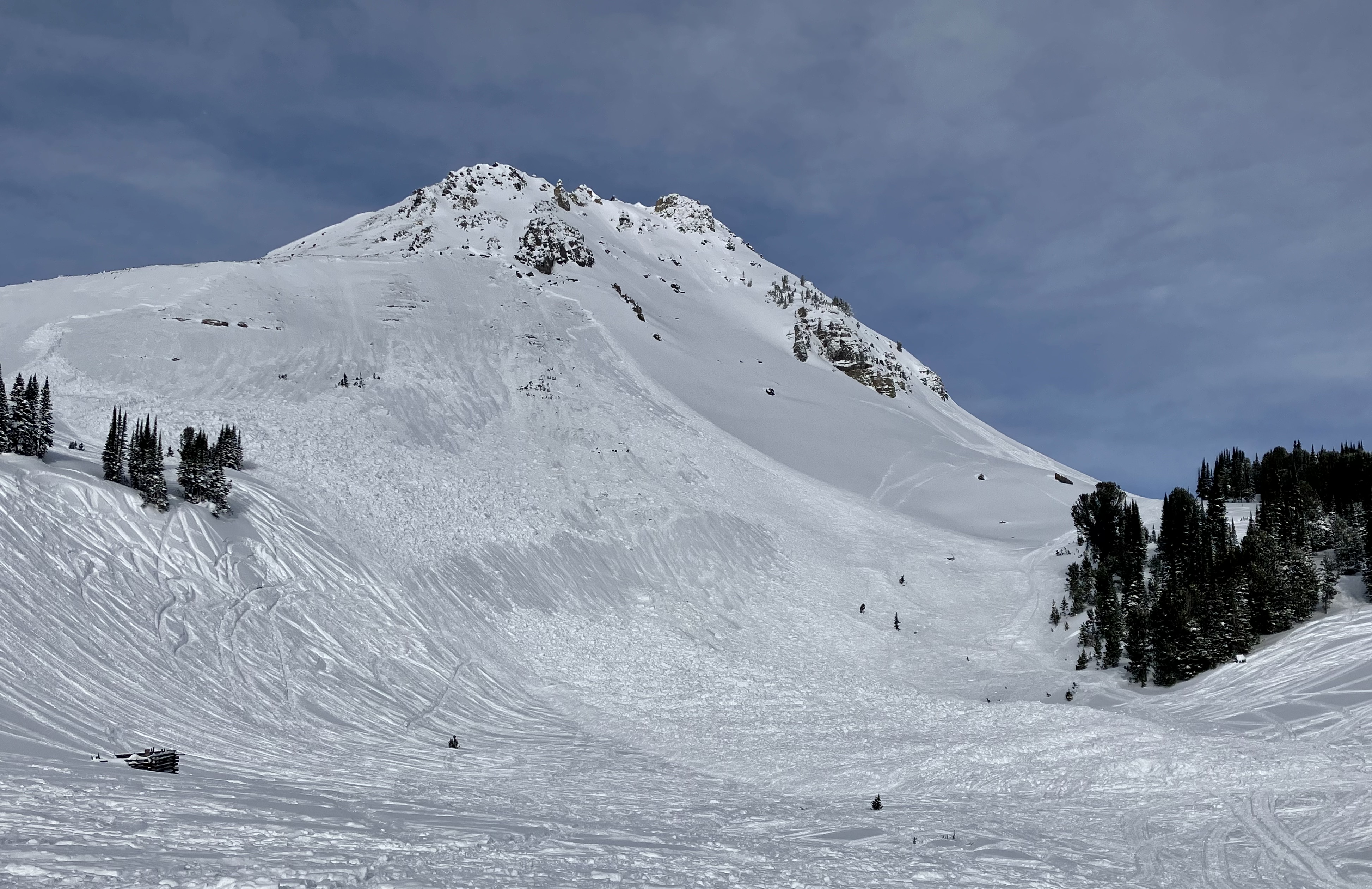
We looked at the avalanche that killed a snowmobiler yesterday (12/31/22) on Crown Butte near Cooke City. It occurred on a southeast facing slope at 9,800 feet elevation. At the crown the avalanche was 1.5-2 feet deep on average, and up to 4 feet at the deepest. It broke 500 feet wide and ran 600 vertical feet. It was a hard slab avalanche that broke on weak, sugary snow, and was large enough to break trees or destroy a car. Our deepest condolences go out to the family and friends of the victim, and those involved with the rescue and recovery.
Full Snow Observation Report