Snow Observations List
We toured into Beehive Basin today and managed to get eyes on aspects throughout Beehive, Bear, and S Fork Spanish Creek Basins. We found excellent turns in spots, variable conditions in others, and a whole lot of rocks still exposed. Gorgeous, clear skies lent themselves to good visibility. Temps were cold at the trailhead but warmed quickly. Winds were predominantly from the South, gusting strong and moving snow around at ridgetops and summits.
Winds seem have impacted upper elevations; low to mid elevations still held soft snow. Outside of true north-facing aspects, most other aspects have seen some wind effect and were in quite variable condition. In the hand pits I dug on several different aspects, I noted light snow atop either sun crusts or wind-blown layers, all with small but well-developed facets underneath. Gullies hold close to a meter of snow but generally, coverage seemed to be around half a meter in depth.
Slab formation was limited to upper elevation ridgelines and little pockets in couloirs. Generally very few signs of instability were seen beyond one small (R1 D1) wind slab avalanche that came down from a rocky, exposed part of the ridgeline into Bear Basin. No surface hoar was noted anywhere. All in all, a lovely day to spend in the Spanish Peaks!
Full Snow Observation ReportIn general, the avalanche danger seemed LOW with isolated terrain features holding potential small wind slabs as the main area of concern.
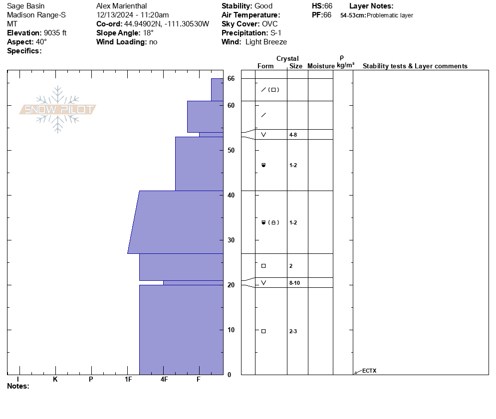
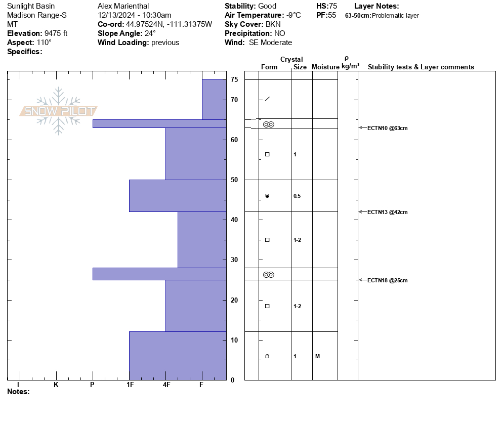
We rode to the Taylor Fork weather station and along the edge of meadows in upper Sage creek. Two snowpits and video attached. Dug one in Sunlight Basin on ESE aspect (near weather station) and one in Sage Creek on NE aspect. ECTNs and ECTX test results.
While riding across Sage Basin we found surface hoar buried 4" deep in most handpits and in our snopwpit, and otherwise 1-2mm facets existed at the same depth.
Snow depth was fairly consistently 2 feet. Trail was thin, but soft and not too bumpy yet.
Wind was light to moderate with some strong gusts near the weather station. Very light snow was falling midday. Mostly cloudy with a few shots of blue sky.
I saw one small old wind slab on a heavily wind loaded short slope at the end of the trail.
Snow stability was good today, but the weak layers near the surface could change that quick depending on how much snow falls this weekend.
Full Snow Observation ReportWe observed snow being moved by wind out of the SW on the very top of lick creek meadow, as well as evidence of previous wind loading at the top of the NE facing side. We didn't get any whumphing or cracking in the spots we skied over.
We also noticed surface hoar in open areas in the approach and a sun crust on the SW facing slope.
Full Snow Observation ReportToured up Blackmore via the south ridge this morning. Winds overnight drifted snow over old tracks and skin tracks around the area. Once on the ridge, I noticed active wind loading on eastern aspects as well as cornices growing along ridge lines.
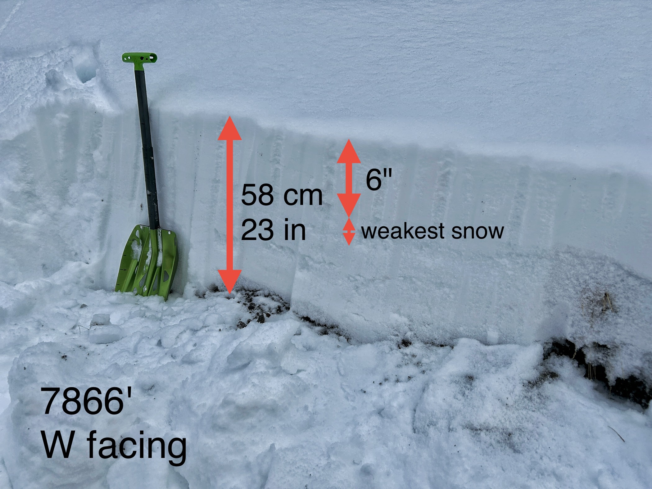
Full Snow Observation ReportChecked out the snow above Mummy 2 and the Scepter. I was surprised how little snow there was, but a lot of it likely melted off during recent warm weather which was amplified by heating of all the surrounding rocks.
The old snow surface from last weekend is faceted but not too bad, and only has 6" of snow on top. The snowpack is generally very discontinuous. Climbers can mostly walk on rocky areas with minimal snow.
My main concern is what will happen when strong south winds arrive on Saturday. Some snow may fall Sunday and south winds may continue. Fresh wind slabs will be the main concern.
**This observation is not very relevant for the snowpack in the upper bowls of Hyalite where many ski**
Full Snow Observation ReportIv been fortunate enough to spend the past three days skiing around hyalite. On Monday, we were skiing a low angle gully a mile NE of Backmore along the ridge. We noticed new snow point and releases on most steep aspects above 40 degrees, no signs of new snow stuff stepping down. Today while on the East Fork ridge south of Palisades mountain, I covered SE-NW aspects and the new snow seemed well bonded. Solar aspects from the high pressure last week had an obvious crust layer, but new snow seemed bonded. On shadier aspects, I felt facets below new snow but no obvious signs of instability.. yet.
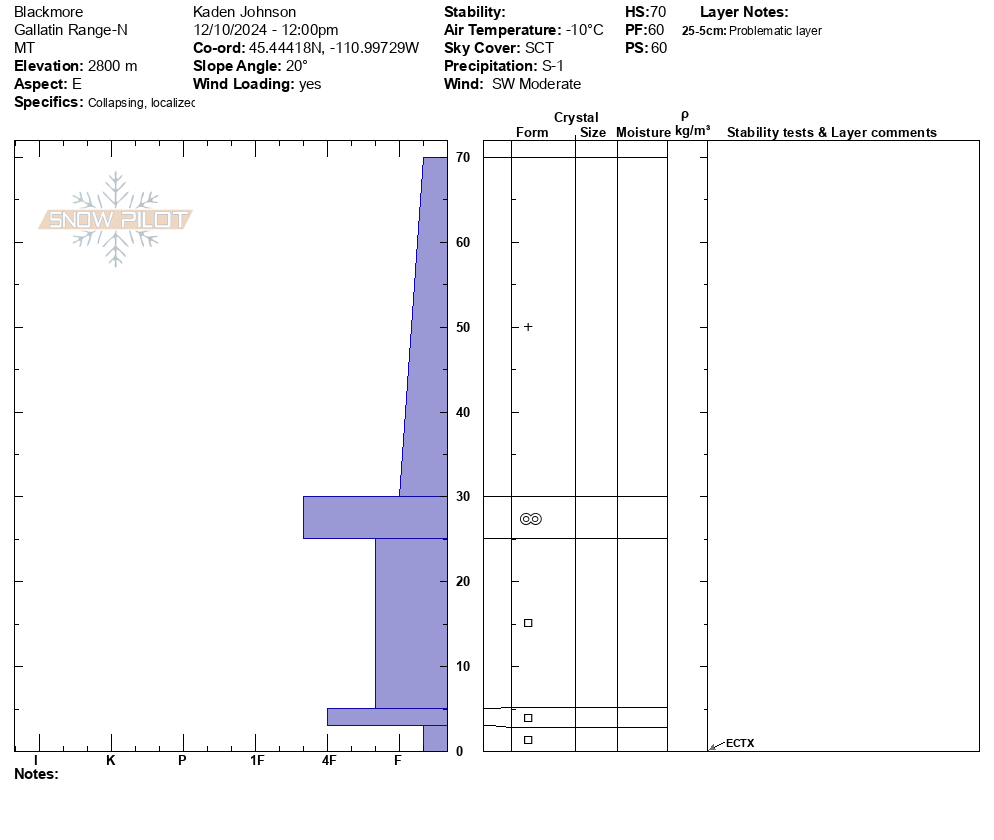
Full Snow Observation ReportSummited Mt. Blackmore 12/10. High wind and heavy wind loading were found, but minimal signs of instability were found within the wind-loaded areas. Some localized cracking and collapsing were observed throughout the boot pack but had minimal propagation. Before the climb, we performed an ECT on a wind loaded slope and found inconclusive results with ECTX.
Full Snow Observation ReportWe skied near Lulu Pass and dug a pit on a northeast facing slope at 9,500'. There was 6-8" of low density new snow on top of a thick layer of surface hoar (10-16mm, photos attached). Snow depth was 90cm. There was a layer of small facets directly below the surface hoar, and below that the snowpack mostly had rounded grains and showed little signs of weakness. We had an ECTN12 on the surface hoar layer. While skiing I saw some 5 foot long cracks across the snow surface on a wind-affected convexity.
I'm not sure how widespread the buried surface hoar is, but this will be our primary interface of concern when we get more snow. We did not find surface hoar on south and west facing terrain in this area, but there was a crust with small facets below it buried 6" deep. Right now there is not quite enough recent new snow to create widespread instability. I do suspect a slab of drifted snow or a wind stiffened slab could propagate easily, especially if it lies on buried surface hoar.
Light snow fell most of the day with maybe an inch of accumulation all day. Wind was light and temps were single digits to low teens. Some moderate gusts in the afternoon, and winds increasing in town this evening.
Full Snow Observation ReportThere was a couple more inches of new snow than I thought based on weather stations. I'm not sure of the weight. It was not visibly very windy today, but it seemed like a MOD on wind-loaded would be appropriate if the winds did much more, as they seem to be doing now... I did not see propagation or obvious signs of instability, but it seemed like SH just needed a little more and it could zip. I could see someone getting surprised if a slope has just a little more snow or slab stiffness.
We rode out of the Buttermilk Trailhead to the old Ski Hill at Lionhead with Gallatin County SAR, Fremont County SAR, and local snowmobile guide from West Yellowstone for our annual West Yellowstone Avalanche Fundamentals class.
It snowed lightly all day without much accumulation (maybe an inch). Winds were stronger than I anticipated, but weren't moving much snow at 8000.' I suspect there was a bit more transport at higher elevations along the ridgeline, but there just isn't much soft snow available for transport. Isolated instability is tied to wind loading. At the Ski Hill breakover, we dug 40 people worth of snow pits. In a couple of them, there was just enough wind loading to get propagating results (ECT16-ECTP24) on basal weak layers.
Recently, buried surface hoar and near surface facets didn't have enough new snow on it to cause problems, but it was preserved under 1-2" of snow.
Full Snow Observation ReportLOW danger still feels correct. Instability seems isolated to areas with sufficient wind loading, it could result in small avalanches.
Skied from Beehive into Middle Basin today. On NE-E aspects there was ~25cm of low density snow over a supportive midpack. On SW-W aspects there was 5-15 cm low density snow over a supportive crust. Moderate NW winds were moving snow, but wind slab formation where we travelled was isolated to immediate ridgetop easterly aspects.
Full Snow Observation ReportWe toured up to Mt Blackmore today to assess how the snowpack is reacting to the recent snowfall. We traveled into the bowl and up the SE face to the ridge. Strong winds were noted off of ridgetops, as well as at lower elevations, before popping out into the bowl. But the SE face below the ridge was remarkably less wind effected than we expected.
The good news: Hyalite was the clear winner from our last storm cycle, and we noted around 15 inches of new snow at 9700'. The bad news: in our snowpit, we got an unstable test result of ECTP 13 on a crust - facet sandwich below the new snow. Unfortunately, the snow that makes up the base of our snowpack is made up of several old crusts and facets.
Where we traveled, we did not note much wind slab formation. Beyond our unstable test result, we did not note any other signs of instability - no recent avalanches or cracking/collapsing beneath our skis.
Full Snow Observation ReportThough we did not find much wind slab formation where we traveled, the winds were gusting strong at ridgetops and certainly blowing snow around. We discussed keeping the forecast CONSIDERABLE on wind-loaded slopes and MODERATE on non-wind-loaded slopes.
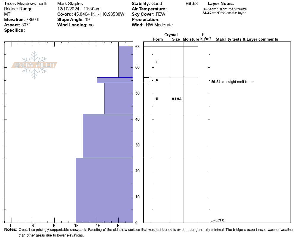
Went north of Bridger Bowl towards Texas Meadows.
Winds - blowing strong at the ridge and below about 7400 feet below most of the avalanche terrain (Top of the Alpine Lift down to the BB base area). Winds not doing much around the elevation of the Bridger Lift and the Ramp.
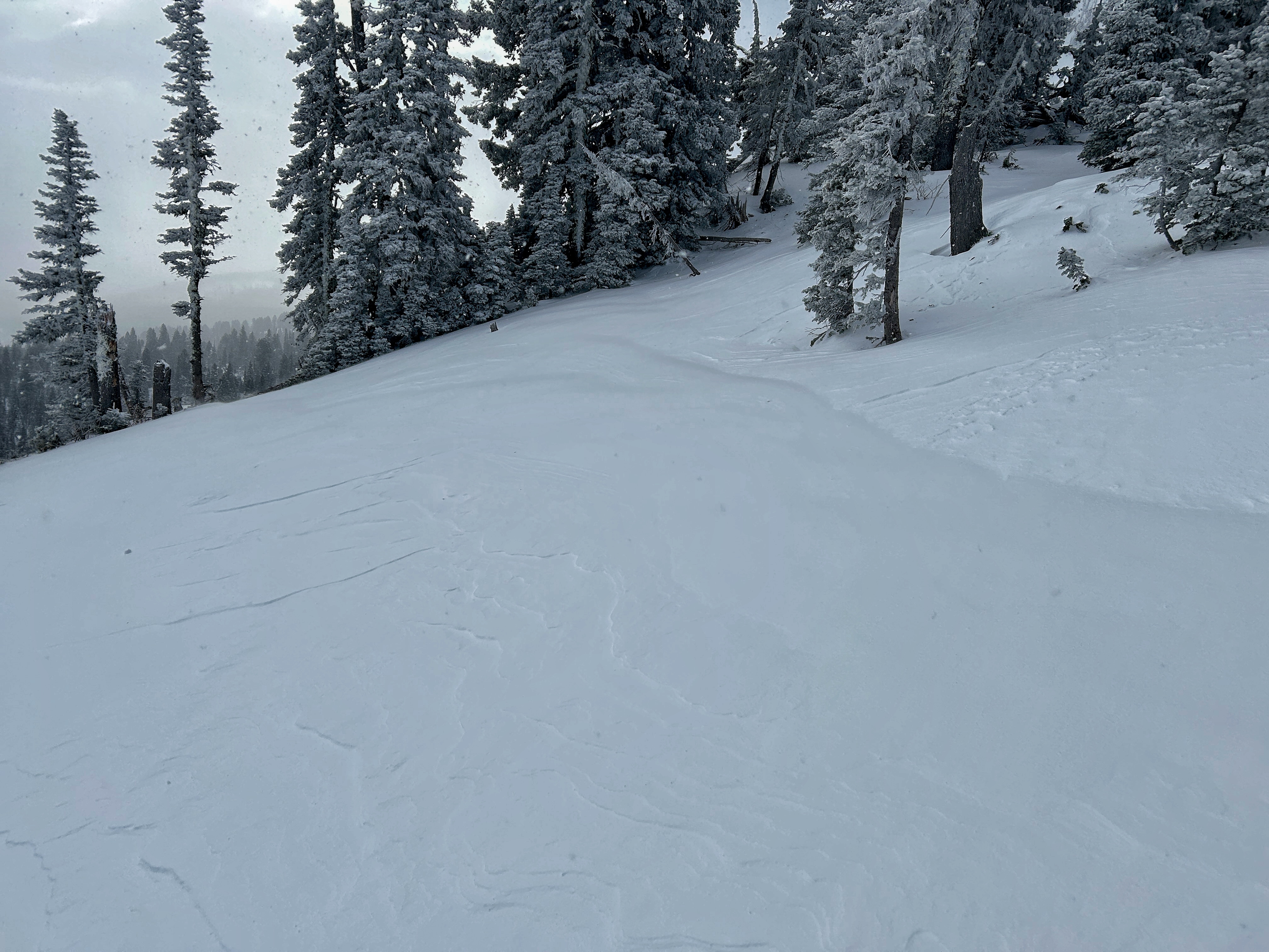
Snow - Just creamy, supportable skiing. South aspects have a supportable melt-freeze crust keeping you off the ground. North aspect have supportable snow. More wind affected areas had alternating scoured snow and wind-deposited snow, but skied pretty well.
Avalanche issues - All tied to the wind. Fresh drifts were easy to find where the wind was blowing. Avoid wind effect and ski/ride soft snow and you avoid avalanches. The old snow surface faceted but not too badly compared to other areas. I suspect you could find areas where the old snow surface was more faceted and weaker, but they seem isolated.
Full Snow Observation Report
Light winds below treeline had little to effect on the snow in the history rock meadows. It was clearly blowing up high, with exposed nw faces stripped of snow and active transport visible off of Blackmore.
Full Snow Observation ReportSkied up through Maid of the Mist Basin into Twin Falls Basin, attempted to boot up the Pinner but was foiled by too much snow. Very strong (almost blew one of my skis away) wind on ridge lines transporting significant amounts of snow. Despite this snow seemed very stable, small wind/storm slab not very consolidated breaking, but not propagating. Skied all sorts of aspects and all angles and saw few signs of instability. Day before friend observed 6-8ft shooting cracks when walking across >30 degree north-eastern aspects near try line, will try to get him to submit video, skied same slope and was unable to replicate a day later. Absurdly deep conditions high up in Hyalite, some of the better turns of my life, hopeful the storm bonds well with previous snow.
Full Snow Observation ReportSkied Candyland near Shower Falls in Hyalite today. Got a decent look around and didn't see any natural avalanches. Got a ECTN12 @ 8k' east facing aspect at Candyland. Fractured at the new snow old snow interface about 40cm down from the surface. 115cm total snow depth. Very soft upper 40cm of snow with firmer snow underneath. Was snowing on and off while I was there and still snowing when I left
Full Snow Observation ReportJust an initial look at low elevation snow around some of the ice climbs.
8" of new snow at the Grotto Falls TH.
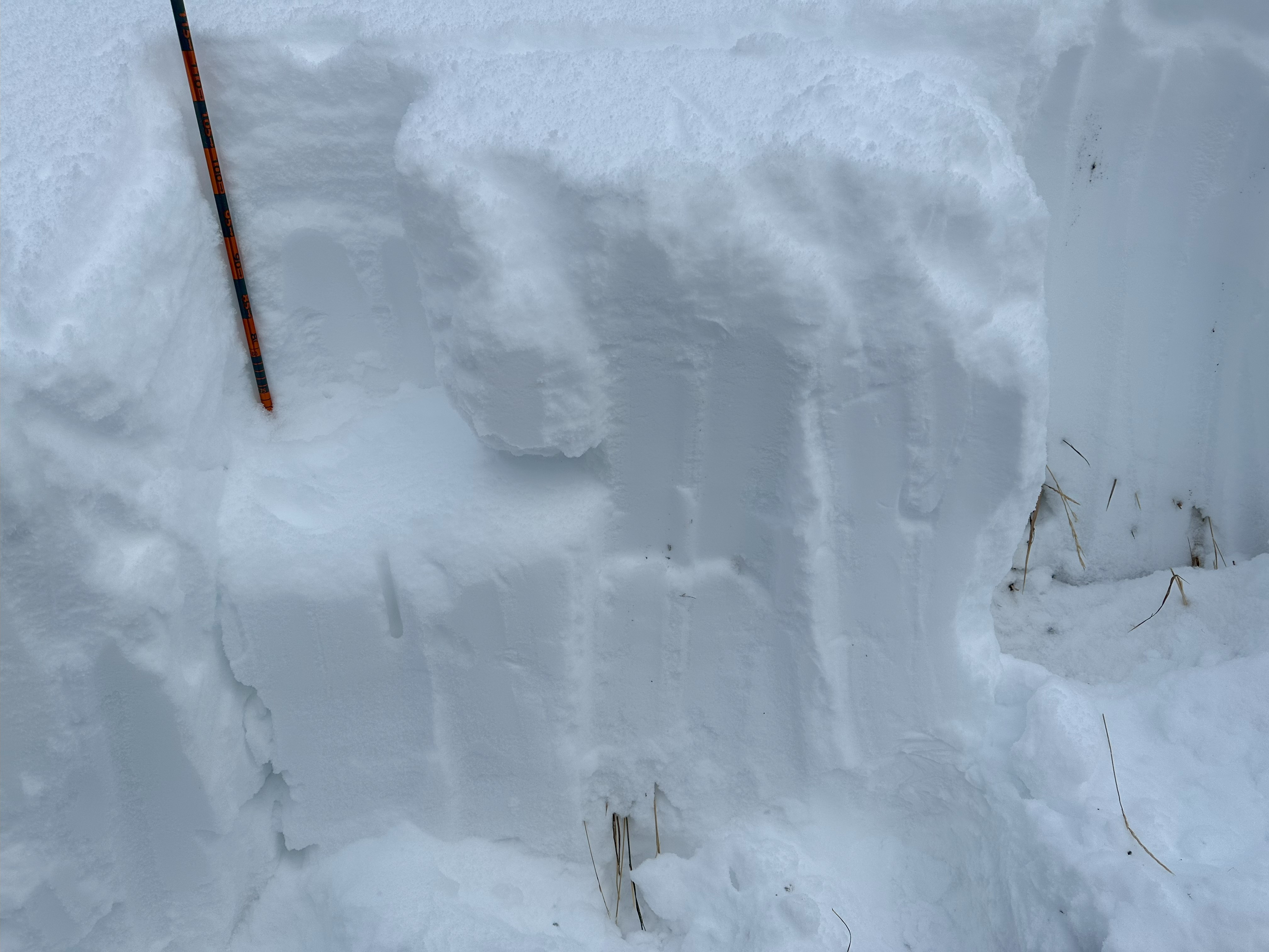
I couldn't find any surface hoar that was buried by last night's snow, but I'm sure it's out there. Doesn't really matter because there's plenty of weak, faceted snow that was the previous snow surface.
The new snow is all fluff and not a concern at lower elevations in Hyalite. Perhaps it could be enough of a load and enough of a cohesive slab at higher elevations where more snow fell.
For now, things seem mostly stable, but that will change quickly with any amount of wind.
Full Snow Observation Report
LOW danger on non-wind load.
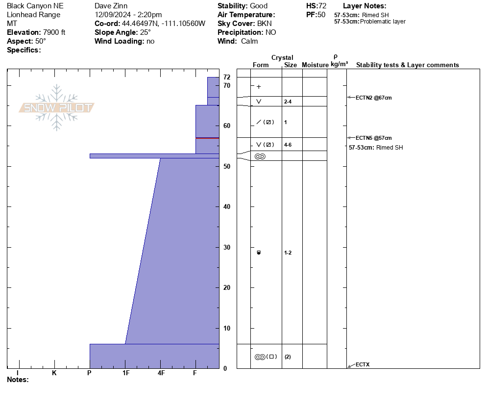
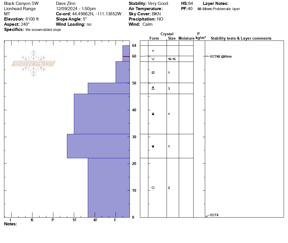
The snowpack remains thin in Island Park. We rode the Big Springs Loop around the Black Canyon area in Island Park. We dug two pits near the top of the loop in the area where one crosses the Canyon. One was on a southwest facing slope and the other on a north-facing slope. Both near 8100' elevation.
The snow depth was 60-70 cm (2-2.5 feet). Surface hoar and near surface facets are now capped by this weekend's snow. The layers are buried 2-4" deep. These are not a concern currently but certainly will become so with the next significant storm (or incremental loading). ECTN2-4 on these layer for now. Winds were calm and avalanches in non-wind-loaded terrain are unlikely. Small areas of isolated instability are possible in higher elevation wind-loaded terrain.
Full Snow Observation ReportWithout significant wind-loading or new snow the danger is LOW. I now have a low threshold for bumping up the danger with preserved surface hoar in the mix.
Noticed this natural avalanche on 12/8. East facing slope, ~9500 feet, Hayden Creek above Ripcurl area
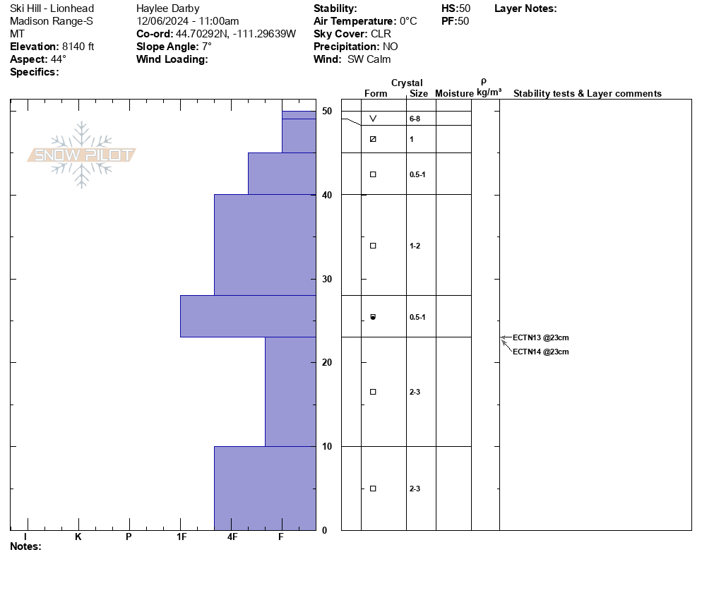
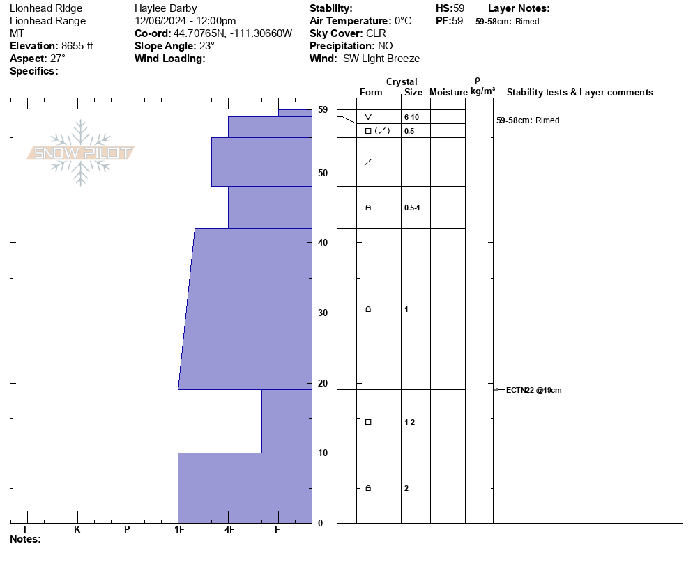
Full Snow Observation ReportWith another day of high pressure and clear skies, Alex and I rode into Lionhead and parked the snowmobiles at the top of Ski Hill. The coverage in and out was decent for this time of year, but thin cover and sharks abound. We dug a snowpit at the top of Ski Hill (8150') and then toured up to the south end of Lionhead Ridge and dug there (8650').
Our snowpits told very similar stories of a weak, layered snowpack from top to bottom: glittering surface hoar on top and different variations of facets to the base. In both snowpits we got ECTN's on interfaces between faceting snow. In our upper pit, we noted a more cohesive slab on top, but it was just not enough to get propagation in that spot.
As we skinned up the ridge, we also noted very isolated collapses, one to two feet from the tips of our skis. But overall, there were no signs of instability, just weak snow, growing weaker by the day.
Until the next round of snowfall, our main hazards continue to be the rocks, trees, and stumps just beneath the surface.
Full Snow Observation ReportWe skied around Scotch Bonnet and Sheep Mtn., north of Cooke City today.
No collapsing nor cracking, nor any avalanche activity observed.
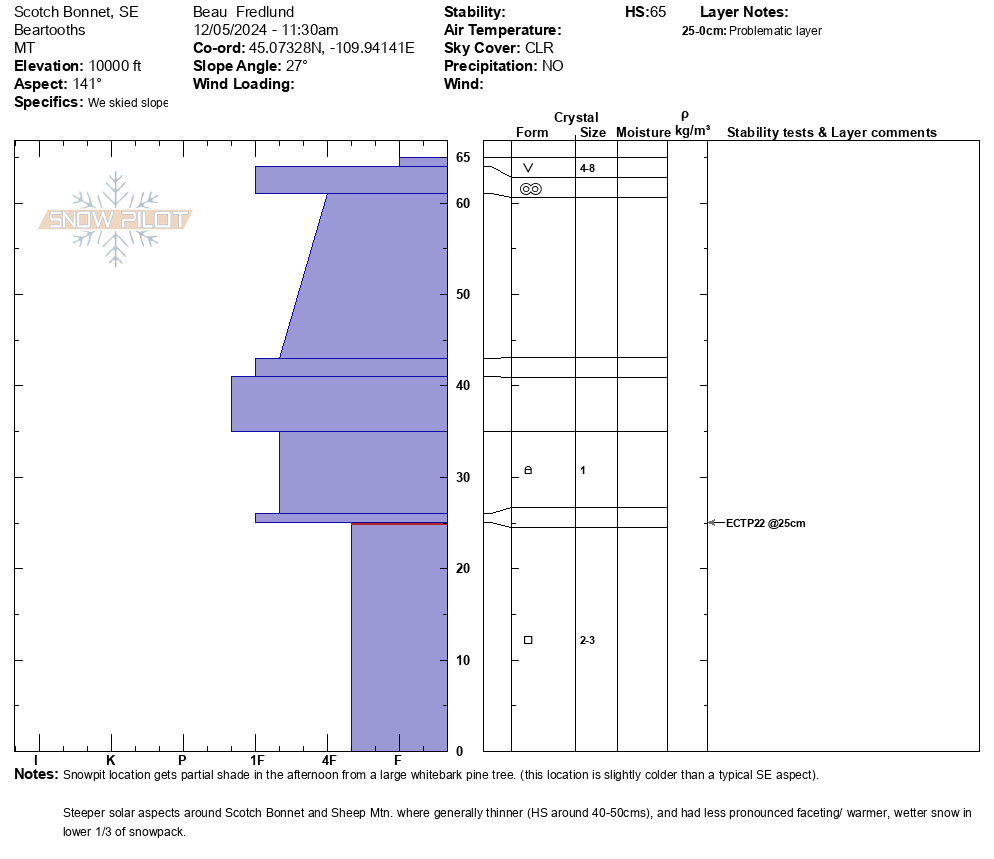
Snow profile attached from a SE aspect at 10,000' on Scotch Bonnet. HS65, ECTP22 @25.
Surface hoar (4-8mm), observed on most slopes, except on steep solar slopes and especially windy locations.
Full Snow Observation Report


